Schellerten geodata
Schellerten (Lower Saxony) is a seat of a fourth-order administrative division; located in Germany in Europe/Berlin (GMT+2) time zone. With population of 8,694 people, there are 1845 cities with bigger population in this country. Compared to other cities in Germany, 73.9% of cities are located further ↓South; 51.7% of cities are located further ←West and 70% of cities have higher elevation than Schellerten. Note1
Administrative division(s):
- Level 1: Lower Saxony
- Level 3: Landkreis Hildesheim
- Level 4: Schellerten


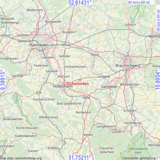
Schellerten GPS coordinates[2]
52° 11' 7.08" North, 10° 6' 8.172" East
| Map corner | latitude | longitude |
|---|---|---|
| Upper-left | 52.61431°, | 9.39915° |
| Center: | 52.1853°, | 10.10227° |
| Lower-right: | 51.75211°, | 10.8054° |
| Map W x H: | 95.9×95.9 km | = 59.6×59.6mi |
| max Lat: | 55.01917° ⇑26.1% North |
| Schellerten: | 52.1853° |
| min Lat: | ⇓73.9% South 47.40724° |
| min Long | Schellerten | max Long |
| 5.92978° | 10.10227° | 14.98853° |
| W 51.7%⇐ | ⇒48.3% E |
Elevation
Elevation of Schellerten is 91 m = 299 ft, and this is 158.1 m = 519 ft below average elevation for this country.
| Max E: |
1256 m = 4121 ft | 70% |
| Avg. | 249.1 m = 817 ft | |
| Schellerten | 91 m = 299 ft | |
Min E: |
-5 m = -16 ft | 30% |
See also: Germany elevation on elevation.city.
Geographical zone
Schellerten is located in North temperate zone (between Tropic of Cancer and the Arctic Circle). Distance of this North polar circle is 1598.7 km =993.4 mi to North.| Distance of | km | miles | from Schellerten |
|---|---|---|---|
| North Pole | 4204.6 | 2612.6 | to North |
| Arctic Circle | 1598.7 | 993.4 | to North |
| Tropic Cancer | 3196.5 | 1986.2 | to South |
| Equator | 5802.5 | 3605.5 | to South |


Nearby cities:
15 places around Schellerten: (largest is in red/bold)
• Algermissen
11.8 km =7.3 mi,  309°
309°
• Bad Salzdetfurth
15.6 km =9.7 mi,  204°
204°
• Baddeckenstedt
14.4 km =8.9 mi,  141°
141°
• Burgdorf
9.1 km =5.7 mi,  120°
120°
• Diekholzen
15.9 km =9.9 mi,  231°
231°
• Giesen
13.9 km =8.6 mi,  275°
275°
• Harsum
9.8 km =6.1 mi,  286°
286°
• Haverlah
13.9 km =8.6 mi,  161°
161°
• Heere
16.6 km =10.3 mi, 142°
• Hildesheim
11 km =6.8 mi,  249°
249°
• Hohenhameln
8.4 km =5.2 mi,  342°
342°
• Holle
11.6 km =7.2 mi, 160°
• Ilsede
10.9 km =6.8 mi,  37°
37°
• Lengede
14.2 km =8.8 mi,  81°
81°
• Söhlde
8.9 km =5.5 mi,  87°
87°
Sources, notices
• [Note1] Compared only with cities in Germany existing in our database
• [Src1] Map data: © OpenStreetMap contributors (CC-BY-SA)
• [Src2] Other city data from geonames.org with taken over terms of usage.
• [Src3] Geographical zone / Annual Mean Temperature by Robert A. Rohde @ Wikipedia
