Rothenberg geodata
Rothenberg (Hesse) is a seat of a fourth-order administrative division; located in Germany in Europe/Berlin (GMT+2) time zone. With population of 2,515 people, there are 4421 cities with bigger population in this country. Compared to other cities in Germany, 75.8% of cities are located further ↑North; 66.4% of cities are located further →East and 77.6% of cities have lower elevation than Rothenberg. Note1
Administrative division(s):
- Level 1: Hesse
- Level 2: Regierungsbezirk Darmstadt
- Level 3: Odenwaldkreis
- Level 4: Oberzent


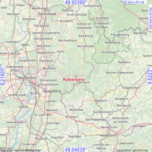
Rothenberg GPS coordinates[2]
49° 29' 57.012" North, 8° 55' 9.012" East
| Map corner | latitude | longitude |
|---|---|---|
| Upper-left | 49.95369°, | 8.21605° |
| Center: | 49.49917°, | 8.91917° |
| Lower-right: | 49.04039°, | 9.6223° |
| Map W x H: | 101.5×101.5 km | = 63.1×63.1mi |
| max Lat: | 55.01917° ⇑75.8% North |
| Rothenberg: | 49.49917° |
| min Lat: | ⇓24.2% South 47.40724° |
| min Long | Rothenberg | max Long |
| 5.92978° | 8.91917° | 14.98853° |
| W 33.6%⇐ | ⇒66.4% E |
Elevation
Elevation of Rothenberg is 416 m = 1365 ft, and this is 166.9 m = 548 ft above average elevation for this country.
| Max E: |
1256 m = 4121 ft | 22.4% |
| Rothenberg | 416 m 1365 ft | |
| Avg. | 249.1 m = 817 ft | |
Min E: |
-5 m = -16 ft | 77.6% |
See also: Germany elevation on elevation.city.
Geographical zone
Rothenberg is located in North temperate zone (between Tropic of Cancer and the Arctic Circle). Distance of this North polar circle is 1897.4 km =1179 mi to North.| Distance of | km | miles | from Rothenberg |
|---|---|---|---|
| North Pole | 4503.3 | 2798.2 | to North |
| Arctic Circle | 1897.4 | 1179 | to North |
| Tropic Cancer | 2897.9 | 1800.7 | to South |
| Equator | 5503.8 | 3419.9 | to South |


Nearby cities:
15 places around Rothenberg: (largest is in red/bold)
• Beerfelden
8.7 km =5.4 mi,  27°
27°
• Eberbach
6.3 km =3.9 mi,  125°
125°
• Heddesbach
6.9 km =4.3 mi,  252°
252°
• Heiligkreuzsteinach
9.1 km =5.7 mi,  258°
258°
• Hesseneck
13 km =8.1 mi,  52°
52°
• Hirschhorn
6.2 km =3.9 mi,  195°
195°
• Lobbach
14 km =8.7 mi,  189°
189°
• Neckargemünd
15.1 km =9.4 mi,  216°
216°
• Neckarsteinach
11.6 km =7.2 mi,  208°
208°
• Neunkirchen
14.1 km =8.8 mi,  152°
152°
• Schönau
10.6 km =6.6 mi,  228°
228°
• Unter-Abtsteinach
10 km =6.2 mi,  288°
288°
• Wald-Michelbach
10.1 km =6.3 mi,  321°
321°
• Wilhelmsfeld
12.4 km =7.7 mi, 255°
• Zwingenberg
12.5 km =7.8 mi,  135°
135°
Sources, notices
• [Note1] Compared only with cities in Germany existing in our database
• [Src1] Map data: © OpenStreetMap contributors (CC-BY-SA)
• [Src2] Other city data from geonames.org with taken over terms of usage.
• [Src3] Geographical zone / Annual Mean Temperature by Robert A. Rohde @ Wikipedia
