Espelkamp geodata
Espelkamp (North Rhine-Westphalia) is a populated place; located in Germany in Europe/Berlin (GMT+2) time zone. With population of 26,378 people, there are 549 cities with bigger population in this country. Compared to other cities in Germany, 76% of cities are located further ↓South; 69.9% of cities are located further →East and 77.9% of cities have higher elevation than Espelkamp. Note1
Administrative division(s):
- Level 1: North Rhine-Westphalia
- Level 2: Regierungsbezirk Detmold
- Level 3: Kreis Minden-Lübbecke
- Level 4: Espelkamp


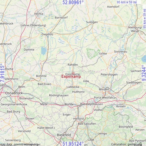
Espelkamp GPS coordinates[2]
52° 22' 57.036" North, 8° 37' 16.572" East
| Map corner | latitude | longitude |
|---|---|---|
| Upper-left | 52.80961°, | 7.91815° |
| Center: | 52.38251°, | 8.62127° |
| Lower-right: | 51.95124°, | 9.3244° |
| Map W x H: | 95.4×95.4 km | = 59.3×59.3mi |
| max Lat: | 55.01917° ⇑24% North |
| Espelkamp: | 52.38251° |
| min Lat: | ⇓76% South 47.40724° |
| min Long | Espelkamp | max Long |
| 5.92978° | 8.62127° | 14.98853° |
| W 30.1%⇐ | ⇒69.9% E |
Elevation
Elevation of Espelkamp is 53 m = 174 ft, and this is 196.1 m = 643 ft below average elevation for this country.
| Max E: |
1256 m = 4121 ft | 77.9% |
| Avg. | 249.1 m = 817 ft | |
| Espelkamp | 53 m = 174 ft | |
Min E: |
-5 m = -16 ft | 22.1% |
See also: Germany elevation on elevation.city.
Geographical zone
Espelkamp is located in North temperate zone (between Tropic of Cancer and the Arctic Circle). Distance of this North polar circle is 1576.8 km =979.8 mi to North.| Distance of | km | miles | from Espelkamp |
|---|---|---|---|
| North Pole | 4182.7 | 2599 | to North |
| Arctic Circle | 1576.8 | 979.8 | to North |
| Tropic Cancer | 3218.5 | 1999.9 | to South |
| Equator | 5824.4 | 3619.1 | to South |


Nearby cities:
15 places around Espelkamp: (largest is in red/bold)
• Bad Holzhausen
11.7 km =7.3 mi,  208°
208°
• Brockum
16.7 km =10.4 mi,  304°
304°
• Bünde
20.6 km =12.8 mi,  186°
186°
• Hille
10.3 km =6.4 mi,  122°
122°
• Hüllhorst
11.5 km =7.1 mi,  164°
164°
• Kirchlengern
20.3 km =12.6 mi,  177°
177°
• Lemförde
19 km =11.8 mi, 299°
• Lübbecke
8.4 km =5.2 mi, 183°
• Preußisch Oldendorf
12.2 km =7.6 mi,  225°
225°
• Quernheim
17.7 km =11 mi, 301°
• Rahden
5.7 km =3.5 mi,  354°
354°
• Rödinghausen
17.5 km =10.9 mi, 212°
• Stemshorn
18.8 km =11.7 mi,  293°
293°
• Wagenfeld
18.8 km =11.7 mi, 352°
• Warmsen
17.6 km =10.9 mi,  61°
61°
Sources, notices
• [Note1] Compared only with cities in Germany existing in our database
• [Src1] Map data: © OpenStreetMap contributors (CC-BY-SA)
• [Src2] Other city data from geonames.org with taken over terms of usage.
• [Src3] Geographical zone / Annual Mean Temperature by Robert A. Rohde @ Wikipedia
