Hirschbach geodata
Hirschbach (Bavaria) is a seat of a fourth-order administrative division; located in Germany in Europe/Berlin (GMT+2) time zone. With population of 1,299 people, there are 6309 cities with bigger population in this country. Compared to other cities in Germany, 74.8% of cities are located further ↑North; 74.7% of cities are located further ←West and 82.3% of cities have lower elevation than Hirschbach. Note1
Administrative division(s):
- Level 1: Bavaria
- Level 2: Upper Palatinate
- Level 3: Landkreis Amberg-Sulzbach
- Level 4: Hirschbach


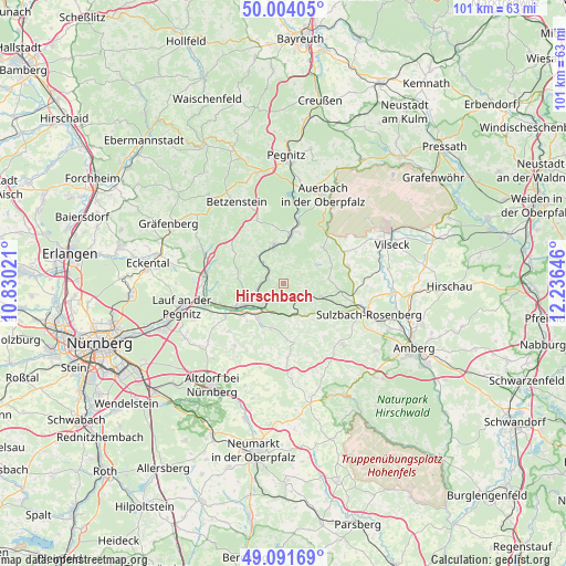
Hirschbach GPS coordinates[2]
49° 33' 0" North, 11° 31' 59.988" East
| Map corner | latitude | longitude |
|---|---|---|
| Upper-left | 50.00405°, | 10.83021° |
| Center: | 49.55°, | 11.53333° |
| Lower-right: | 49.09169°, | 12.23646° |
| Map W x H: | 101.4×101.4 km | = 63×63mi |
| max Lat: | 55.01917° ⇑74.8% North |
| Hirschbach: | 49.55° |
| min Lat: | ⇓25.2% South 47.40724° |
| min Long | Hirschbach | max Long |
| 5.92978° | 11.53333° | 14.98853° |
| W 74.7%⇐ | ⇒25.3% E |
Elevation
Elevation of Hirschbach is 448 m = 1470 ft, and this is 198.9 m = 653 ft above average elevation for this country.
| Max E: |
1256 m = 4121 ft | 17.7% |
| Hirschbach | 448 m 1470 ft | |
| Avg. | 249.1 m = 817 ft | |
Min E: |
-5 m = -16 ft | 82.3% |
See also: Germany elevation on elevation.city.
Geographical zone
Hirschbach is located in North temperate zone (between Tropic of Cancer and the Arctic Circle). Distance of this North polar circle is 1891.7 km =1175.4 mi to North.| Distance of | km | miles | from Hirschbach |
|---|---|---|---|
| North Pole | 4497.6 | 2794.7 | to North |
| Arctic Circle | 1891.7 | 1175.4 | to North |
| Tropic Cancer | 2903.5 | 1804.2 | to South |
| Equator | 5509.4 | 3423.4 | to South |


Nearby cities:
15 places around Hirschbach: (largest is in red/bold)
• Alfeld
13 km =8.1 mi,  174°
174°
• Edelsfeld
12.1 km =7.5 mi,  75°
75°
• Etzelwang
4.5 km =2.8 mi,  123°
123°
• Happurg
7.7 km =4.8 mi,  215°
215°
• Hartenstein
5.7 km =3.5 mi,  347°
347°
• Henfenfeld
11.8 km =7.3 mi,  240°
240°
• Hersbruck
8.5 km =5.3 mi, 239°
• Kirchensittenbach
8 km =5 mi,  274°
274°
• Königstein
9.6 km =6 mi,  47°
47°
• Neuhaus an der Pegnitz
8.8 km =5.5 mi,  8°
8°
• Pommelsbrunn
5.3 km =3.3 mi,  197°
197°
• Reichenschwand
12.3 km =7.6 mi,  250°
250°
• Velden
7.3 km =4.5 mi, 346°
• Vorra
2.9 km =1.8 mi,  285°
285°
• Weigendorf
6.3 km =3.9 mi,  156°
156°
Sources, notices
• [Note1] Compared only with cities in Germany existing in our database
• [Src1] Map data: © OpenStreetMap contributors (CC-BY-SA)
• [Src2] Other city data from geonames.org with taken over terms of usage.
• [Src3] Geographical zone / Annual Mean Temperature by Robert A. Rohde @ Wikipedia
