Weigendorf geodata
Weigendorf (Bavaria) is a seat of a fourth-order administrative division; located in Germany in Europe/Berlin (GMT+2) time zone. With population of 1,292 people, there are 6332 cities with bigger population in this country. Compared to other cities in Germany, 75.8% of cities are located further ↑North; 75.4% of cities are located further ←West and 76.1% of cities have lower elevation than Weigendorf. Note1
Administrative division(s):
- Level 1: Bavaria
- Level 2: Upper Palatinate
- Level 3: Landkreis Amberg-Sulzbach
- Level 4: Weigendorf


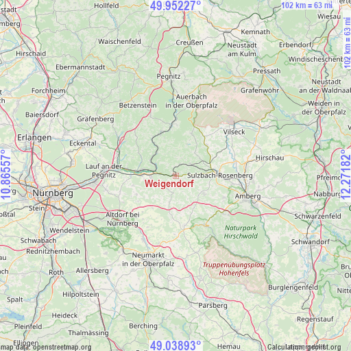
Weigendorf GPS coordinates[2]
49° 29' 51.828" North, 11° 34' 7.284" East
| Map corner | latitude | longitude |
|---|---|---|
| Upper-left | 49.95227°, | 10.86557° |
| Center: | 49.49773°, | 11.56869° |
| Lower-right: | 49.03893°, | 12.27182° |
| Map W x H: | 101.6×101.6 km | = 63.1×63.1mi |
| max Lat: | 55.01917° ⇑75.8% North |
| Weigendorf: | 49.49773° |
| min Lat: | ⇓24.2% South 47.40724° |
| min Long | Weigendorf | max Long |
| 5.92978° | 11.56869° | 14.98853° |
| W 75.4%⇐ | ⇒24.6% E |
Elevation
Elevation of Weigendorf is 406 m = 1332 ft, and this is 156.9 m = 515 ft above average elevation for this country.
| Max E: |
1256 m = 4121 ft | 23.9% |
| Weigendorf | 406 m 1332 ft | |
| Avg. | 249.1 m = 817 ft | |
Min E: |
-5 m = -16 ft | 76.1% |
See also: Germany elevation on elevation.city.
Geographical zone
Weigendorf is located in North temperate zone (between Tropic of Cancer and the Arctic Circle). Distance of this North polar circle is 1897.5 km =1179.1 mi to North.| Distance of | km | miles | from Weigendorf |
|---|---|---|---|
| North Pole | 4503.4 | 2798.3 | to North |
| Arctic Circle | 1897.5 | 1179.1 | to North |
| Tropic Cancer | 2897.7 | 1800.5 | to South |
| Equator | 5503.6 | 3419.8 | to South |


Nearby cities:
15 places around Weigendorf: (largest is in red/bold)
• Alfeld
7.3 km =4.5 mi,  190°
190°
• Edelsfeld
12.7 km =7.9 mi,  46°
46°
• Engelthal
12.6 km =7.8 mi,  256°
256°
• Etzelwang
3.5 km =2.2 mi,  20°
20°
• Happurg
7.1 km =4.4 mi,  266°
266°
• Hartenstein
12 km =7.5 mi,  341°
341°
• Henfenfeld
12.9 km =8 mi, 270°
• Hersbruck
10 km =6.2 mi,  278°
278°
• Hirschbach
6.3 km =3.9 mi, 336°
• Illschwang
9.8 km =6.1 mi,  122°
122°
• Kirchensittenbach
12.4 km =7.7 mi,  301°
301°
• Offenhausen
12.4 km =7.7 mi,  244°
244°
• Pommelsbrunn
4.2 km =2.6 mi, 280°
• Sulzbach-Rosenberg
12.8 km =8 mi,  88°
88°
• Vorra
8.5 km =5.3 mi,  320°
320°
Sources, notices
• [Note1] Compared only with cities in Germany existing in our database
• [Src1] Map data: © OpenStreetMap contributors (CC-BY-SA)
• [Src2] Other city data from geonames.org with taken over terms of usage.
• [Src3] Geographical zone / Annual Mean Temperature by Robert A. Rohde @ Wikipedia
