Herrenhof geodata
Herrenhof (Thuringia) is a seat of a fourth-order administrative division; located in Germany in Europe/Berlin (GMT+2) time zone. With population of 808 people, there are 7863 cities with bigger population in this country. Compared to other cities in Germany, 55% of cities are located further ↓South; 62.3% of cities are located further ←West and 70.6% of cities have lower elevation than Herrenhof. Note1


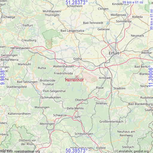
Herrenhof GPS coordinates[2]
50° 50' 30.624" North, 10° 41' 12.948" East
| Map corner | latitude | longitude |
|---|---|---|
| Upper-left | 51.28373°, | 9.9838° |
| Center: | 50.84184°, | 10.68693° |
| Lower-right: | 50.39573°, | 11.39006° |
| Map W x H: | 98.7×98.7 km | = 61.3×61.3mi |
| max Lat: | 55.01917° ⇑45% North |
| Herrenhof: | 50.84184° |
| min Lat: | ⇓55% South 47.40724° |
| min Long | Herrenhof | max Long |
| 5.92978° | 10.68693° | 14.98853° |
| W 62.3%⇐ | ⇒37.7% E |
Elevation
Elevation of Herrenhof is 363 m = 1191 ft, and this is 113.9 m = 374 ft above average elevation for this country.
| Max E: |
1256 m = 4121 ft | 29.4% |
| Herrenhof | 363 m 1191 ft | |
| Avg. | 249.1 m = 817 ft | |
Min E: |
-5 m = -16 ft | 70.6% |
See also: Germany elevation on elevation.city.
Geographical zone
Herrenhof is located in North temperate zone (between Tropic of Cancer and the Arctic Circle). Distance of this North polar circle is 1748.1 km =1086.2 mi to North.| Distance of | km | miles | from Herrenhof |
|---|---|---|---|
| North Pole | 4354 | 2705.4 | to North |
| Arctic Circle | 1748.1 | 1086.2 | to North |
| Tropic Cancer | 3047.2 | 1893.4 | to South |
| Equator | 5653.1 | 3512.7 | to South |


Nearby cities:
15 places around Herrenhof: (largest is in red/bold)
• Crawinkel
9.4 km =5.8 mi,  133°
133°
• Emleben
5.9 km =3.7 mi,  10°
10°
• Ernstroda
5.3 km =3.3 mi,  298°
298°
• Finsterbergen
6.9 km =4.3 mi,  263°
263°
• Friedrichroda
8.7 km =5.4 mi,  281°
281°
• Georgenthal
2 km =1.2 mi,  237°
237°
• Gräfenhain
2.9 km =1.8 mi,  161°
161°
• Hohenkirchen
1.3 km =0.8 mi,  45°
45°
• Hörselgau
11.3 km =7 mi,  320°
320°
• Luisenthal
7.3 km =4.5 mi,  153°
153°
• Petriroda
2.9 km =1.8 mi,  18°
18°
• Schwabhausen
6 km =3.7 mi,  30°
30°
• Tambach-Dietharz
7.4 km =4.6 mi,  222°
222°
• Waltershausen
11 km =6.8 mi, 304°
• Wölfis
7.5 km =4.7 mi,  119°
119°
Sources, notices
• [Note1] Compared only with cities in Germany existing in our database
• [Src1] Map data: © OpenStreetMap contributors (CC-BY-SA)
• [Src2] Other city data from geonames.org with taken over terms of usage.
• [Src3] Geographical zone / Annual Mean Temperature by Robert A. Rohde @ Wikipedia
