Ernstroda geodata
Ernstroda (Thuringia) is a populated place; located in Germany in Europe/Berlin (GMT+2) time zone. With population of 1,044 people, there are 7030 cities with bigger population in this country. Compared to other cities in Germany, 55.4% of cities are located further ↓South; 61.2% of cities are located further ←West and 70.4% of cities have lower elevation than Ernstroda. Note1


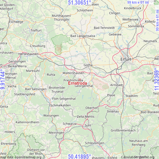
Ernstroda GPS coordinates[2]
50° 51' 53.424" North, 10° 37' 14.016" East
| Map corner | latitude | longitude |
|---|---|---|
| Upper-left | 51.30651°, | 9.91744° |
| Center: | 50.86484°, | 10.62056° |
| Lower-right: | 50.41895°, | 11.32369° |
| Map W x H: | 98.7×98.7 km | = 61.3×61.3mi |
| max Lat: | 55.01917° ⇑44.6% North |
| Ernstroda: | 50.86484° |
| min Lat: | ⇓55.4% South 47.40724° |
| min Long | Ernstroda | max Long |
| 5.92978° | 10.62056° | 14.98853° |
| W 61.2%⇐ | ⇒38.8% E |
Elevation
Elevation of Ernstroda is 361 m = 1184 ft, and this is 111.9 m = 367 ft above average elevation for this country.
| Max E: |
1256 m = 4121 ft | 29.6% |
| Ernstroda | 361 m 1184 ft | |
| Avg. | 249.1 m = 817 ft | |
Min E: |
-5 m = -16 ft | 70.4% |
See also: Germany elevation on elevation.city.
Geographical zone
Ernstroda is located in North temperate zone (between Tropic of Cancer and the Arctic Circle). Distance of this North polar circle is 1745.5 km =1084.6 mi to North.| Distance of | km | miles | from Ernstroda |
|---|---|---|---|
| North Pole | 4351.4 | 2703.8 | to North |
| Arctic Circle | 1745.5 | 1084.6 | to North |
| Tropic Cancer | 3049.7 | 1895 | to South |
| Equator | 5655.6 | 3514.2 | to South |


Nearby cities:
15 places around Ernstroda: (largest is in red/bold)
• Emleben
6.6 km =4.1 mi,  60°
60°
• Finsterbergen
4 km =2.5 mi,  213°
213°
• Friedrichroda
4 km =2.5 mi,  258°
258°
• Georgenthal
4.7 km =2.9 mi,  140°
140°
• Gotha
10.9 km =6.8 mi,  31°
31°
• Gräfenhain
7.7 km =4.8 mi,  133°
133°
• Herrenhof
5.3 km =3.3 mi,  118°
118°
• Hohenkirchen
5.8 km =3.6 mi,  106°
106°
• Hörselgau
6.6 km =4.1 mi,  337°
337°
• Laucha
8.7 km =5.4 mi,  321°
321°
• Petriroda
5.6 km =3.5 mi,  87°
87°
• Schwabhausen
8.2 km =5.1 mi,  71°
71°
• Tabarz
7.4 km =4.6 mi,  279°
279°
• Tambach-Dietharz
8.1 km =5 mi,  182°
182°
• Waltershausen
5.8 km =3.6 mi,  310°
310°
Sources, notices
• [Note1] Compared only with cities in Germany existing in our database
• [Src1] Map data: © OpenStreetMap contributors (CC-BY-SA)
• [Src2] Other city data from geonames.org with taken over terms of usage.
• [Src3] Geographical zone / Annual Mean Temperature by Robert A. Rohde @ Wikipedia
