Friedrichroda geodata
Friedrichroda (Thuringia) is a populated place; located in Germany in Europe/Berlin (GMT+2) time zone. With population of 5,492 people, there are 2629 cities with bigger population in this country. Compared to other cities in Germany, 55.3% of cities are located further ↓South; 60.1% of cities are located further ←West and 79.1% of cities have lower elevation than Friedrichroda. Note1


Friedrichroda GPS coordinates[2]
50° 51' 27.144" North, 10° 33' 54.252" East
| Map corner | latitude | longitude |
|---|---|---|
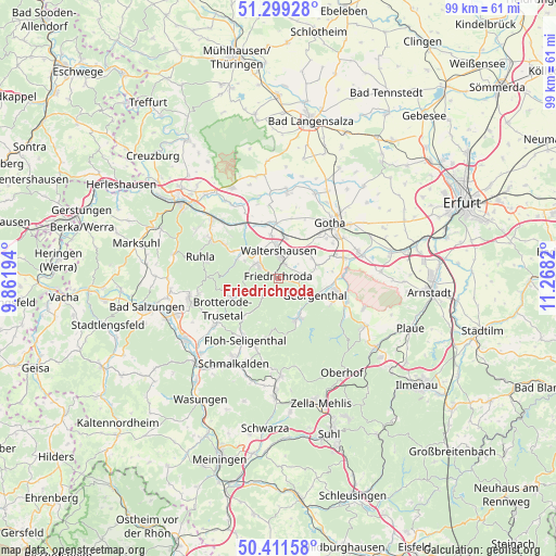
| Upper-left | 51.29928°, | 9.86194° |
| Center: | 50.85754°, | 10.56507° |
| Lower-right: | 50.41158°, | 11.2682° |
| Map W x H: | 98.7×98.7 km | = 61.3×61.3mi |
| max Lat: | 55.01917° ⇑44.7% North |
| Friedrichroda: | 50.85754° |
| min Lat: | ⇓55.3% South 47.40724° |
| min Long | Friedrichroda | max Long |
| 5.92978° | 10.56507° | 14.98853° |
| W 60.1%⇐ | ⇒39.9% E |
Elevation
Elevation of Friedrichroda is 428 m = 1404 ft, and this is 178.9 m = 587 ft above average elevation for this country.
| Max E: |
1256 m = 4121 ft | 20.9% |
| Friedrichroda | 428 m 1404 ft | |
| Avg. | 249.1 m = 817 ft | |
Min E: |
-5 m = -16 ft | 79.1% |
See also: Germany elevation on elevation.city.
Geographical zone
Friedrichroda is located in North temperate zone (between Tropic of Cancer and the Arctic Circle). Distance of this North polar circle is 1746.3 km =1085.1 mi to North.| Distance of | km | miles | from Friedrichroda |
|---|---|---|---|
| North Pole | 4352.2 | 2704.3 | to North |
| Arctic Circle | 1746.3 | 1085.1 | to North |
| Tropic Cancer | 3048.9 | 1894.5 | to South |
| Equator | 5654.8 | 3513.7 | to South |


Nearby cities:
15 places around Friedrichroda: (largest is in red/bold)
• Brotterode
9.2 km =5.7 mi,  246°
246°
• Emleben
10.5 km =6.5 mi,  67°
67°
• Ernstroda
4 km =2.5 mi,  78°
78°
• Finsterbergen
3.1 km =1.9 mi,  146°
146°
• Georgenthal
7.4 km =4.6 mi,  112°
112°
• Herrenhof
8.7 km =5.4 mi,  101°
101°
• Hohenkirchen
9.5 km =5.9 mi, 95°
• Hörselgau
7.1 km =4.4 mi,  11°
11°
• Laucha
7.7 km =4.8 mi,  348°
348°
• Mechterstädt
9.8 km =6.1 mi,  342°
342°
• Pappenheim
9.3 km =5.8 mi,  222°
222°
• Petriroda
9.5 km =5.9 mi, 83°
• Tabarz
4 km =2.5 mi,  299°
299°
• Tambach-Dietharz
8.1 km =5 mi, 153°
• Waltershausen
4.6 km =2.9 mi, 353°
Sources, notices
• [Note1] Compared only with cities in Germany existing in our database
• [Src1] Map data: © OpenStreetMap contributors (CC-BY-SA)
• [Src2] Other city data from geonames.org with taken over terms of usage.
• [Src3] Geographical zone / Annual Mean Temperature by Robert A. Rohde @ Wikipedia
