Tambach-Dietharz geodata
Tambach-Dietharz (Thuringia) is a populated place; located in Germany in Europe/Berlin (GMT+2) time zone. With population of 4,354 people, there are 3110 cities with bigger population in this country. Compared to other cities in Germany, 54% of cities are located further ↓South; 61% of cities are located further ←West and 83.6% of cities have lower elevation than Tambach-Dietharz. Note1
Administrative division(s):
- Level 1: Thuringia
- Level 3: Landkreis Gotha
- Level 4: Tambach-Dietharz/Thür. Wald


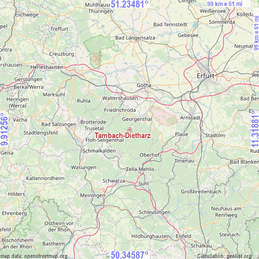
Tambach-Dietharz GPS coordinates[2]
50° 47' 32.82" North, 10° 36' 56.448" East
| Map corner | latitude | longitude |
|---|---|---|
| Upper-left | 51.23481°, | 9.91256° |
| Center: | 50.79245°, | 10.61568° |
| Lower-right: | 50.34587°, | 11.31881° |
| Map W x H: | 98.8×98.8 km | = 61.4×61.4mi |
| max Lat: | 55.01917° ⇑46% North |
| Tambach-Dietharz: | 50.79245° |
| min Lat: | ⇓54% South 47.40724° |
| min Long | Tambach-Diethar | max Long |
| 5.92978° | 10.61568° | 14.98853° |
| W 61%⇐ | ⇒39% E |
Elevation
Elevation of Tambach-Dietharz is 458 m = 1503 ft, and this is 208.9 m = 685 ft above average elevation for this country.
| Max E: |
1256 m = 4121 ft | 16.4% |
| Tambach-Dietharz | 458 m 1503 ft | |
| Avg. | 249.1 m = 817 ft | |
Min E: |
-5 m = -16 ft | 83.6% |
See also: Germany elevation on elevation.city.
Geographical zone
Tambach-Dietharz is located in North temperate zone (between Tropic of Cancer and the Arctic Circle). Distance of this North polar circle is 1753.6 km =1089.6 mi to North.| Distance of | km | miles | from Tambach-Dietharz |
|---|---|---|---|
| North Pole | 4359.5 | 2708.9 | to North |
| Arctic Circle | 1753.6 | 1089.6 | to North |
| Tropic Cancer | 3041.7 | 1890 | to South |
| Equator | 5647.6 | 3509.3 | to South |


Nearby cities:
15 places around Tambach-Dietharz: (largest is in red/bold)
• Ernstroda
8.1 km =5 mi,  2°
2°
• Finsterbergen
5 km =3.1 mi,  338°
338°
• Friedrichroda
8.1 km =5 mi,  333°
333°
• Georgenthal
5.5 km =3.4 mi,  36°
36°
• Gräfenhain
6.5 km =4 mi,  65°
65°
• Herrenhof
7.4 km =4.6 mi, 42°
• Hohenkirchen
8.7 km =5.4 mi, 42°
• Luisenthal
8.3 km =5.2 mi,  96°
96°
• Oberschönau
8.4 km =5.2 mi,  179°
179°
• Pappenheim
9.9 km =6.2 mi,  272°
272°
• Petriroda
10.2 km =6.3 mi, 35°
• Rotterode
9.9 km =6.2 mi,  206°
206°
• Steinbach-Hallenberg
11.3 km =7 mi,  198°
198°
• Unterschönau
8.7 km =5.4 mi, 195°
• Wölfis
11.6 km =7.2 mi,  81°
81°
Sources, notices
• [Note1] Compared only with cities in Germany existing in our database
• [Src1] Map data: © OpenStreetMap contributors (CC-BY-SA)
• [Src2] Other city data from geonames.org with taken over terms of usage.
• [Src3] Geographical zone / Annual Mean Temperature by Robert A. Rohde @ Wikipedia
