Wald-Michelbach geodata
Wald-Michelbach (Hesse) is a seat of a fourth-order administrative division; located in Germany in Europe/Berlin (GMT+2) time zone. With population of 11,720 people, there are 1401 cities with bigger population in this country. Compared to other cities in Germany, 74.4% of cities are located further ↑North; 67.6% of cities are located further →East and 67.5% of cities have lower elevation than Wald-Michelbach. Note1
Administrative division(s):
- Level 1: Hesse
- Level 2: Regierungsbezirk Darmstadt
- Level 3: Landkreis Bergstraße
- Level 4: Wald-Michelbach


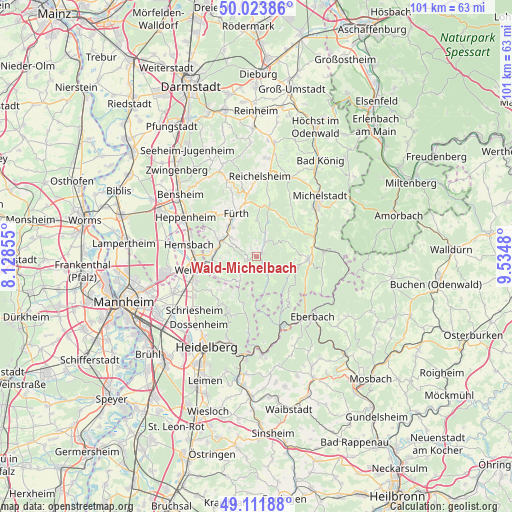
Wald-Michelbach GPS coordinates[2]
49° 34' 12" North, 8° 49' 54.012" East
| Map corner | latitude | longitude |
|---|---|---|
| Upper-left | 50.02386°, | 8.12855° |
| Center: | 49.57°, | 8.83167° |
| Lower-right: | 49.11188°, | 9.5348° |
| Map W x H: | 101.4×101.4 km | = 63×63mi |
| max Lat: | 55.01917° ⇑74.4% North |
| Wald-Michelbach: | 49.57° |
| min Lat: | ⇓25.6% South 47.40724° |
| min Long | Wald-Michelbach | max Long |
| 5.92978° | 8.83167° | 14.98853° |
| W 32.4%⇐ | ⇒67.6% E |
Elevation
Elevation of Wald-Michelbach is 339 m = 1112 ft, and this is 89.9 m = 295 ft above average elevation for this country.
| Max E: |
1256 m = 4121 ft | 32.5% |
| Wald-Michelbach | 339 m 1112 ft | |
| Avg. | 249.1 m = 817 ft | |
Min E: |
-5 m = -16 ft | 67.5% |
See also: Germany elevation on elevation.city.
Geographical zone
Wald-Michelbach is located in North temperate zone (between Tropic of Cancer and the Arctic Circle). Distance of this North polar circle is 1889.5 km =1174.1 mi to North.| Distance of | km | miles | from Wald-Michelbach |
|---|---|---|---|
| North Pole | 4495.4 | 2793.3 | to North |
| Arctic Circle | 1889.5 | 1174.1 | to North |
| Tropic Cancer | 2905.7 | 1805.5 | to South |
| Equator | 5511.7 | 3424.8 | to South |


Nearby cities:
15 places around Wald-Michelbach: (largest is in red/bold)
• Beerfelden
10.3 km =6.4 mi,  90°
90°
• Birkenau
9 km =5.6 mi,  264°
264°
• Fürth
9.6 km =6 mi,  339°
339°
• Heddesbach
10 km =6.2 mi,  181°
181°
• Heiligkreuzsteinach
10 km =6.2 mi,  195°
195°
• Hemsbach
13.5 km =8.4 mi,  279°
279°
• Hirschberg an der Bergstraße
14.4 km =8.9 mi,  240°
240°
• Laudenbach
13.7 km =8.5 mi,  290°
290°
• Lindenfels
13.1 km =8.1 mi, 344°
• Mörlenbach
7.7 km =4.8 mi, 294°
• Rimbach
7.9 km =4.9 mi,  321°
321°
• Rothenberg
10.1 km =6.3 mi,  141°
141°
• Unter-Abtsteinach
5.8 km =3.6 mi,  214°
214°
• Weinheim
12.1 km =7.5 mi, 258°
• Wilhelmsfeld
12.4 km =7.7 mi, 207°
Sources, notices
• [Note1] Compared only with cities in Germany existing in our database
• [Src1] Map data: © OpenStreetMap contributors (CC-BY-SA)
• [Src2] Other city data from geonames.org with taken over terms of usage.
• [Src3] Geographical zone / Annual Mean Temperature by Robert A. Rohde @ Wikipedia
