Wintzingerode geodata
Wintzingerode (Thuringia) is a populated place; located in Germany in Europe/Berlin (GMT+2) time zone. With population of 582 people, there are 8909 cities with bigger population in this country. Compared to other cities in Germany, 65.4% of cities are located further ↓South; 56.1% of cities are located further ←West and 59.4% of cities have lower elevation than Wintzingerode. Note1


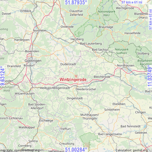
Wintzingerode GPS coordinates[2]
51° 26' 35.52" North, 10° 20' 3.696" East
| Map corner | latitude | longitude |
|---|---|---|
| Upper-left | 51.87935°, | 9.63124° |
| Center: | 51.4432°, | 10.33436° |
| Lower-right: | 51.00284°, | 11.03749° |
| Map W x H: | 97.5×97.5 km | = 60.6×60.6mi |
| max Lat: | 55.01917° ⇑34.6% North |
| Wintzingerode: | 51.4432° |
| min Lat: | ⇓65.4% South 47.40724° |
| min Long | Wintzingerode | max Long |
| 5.92978° | 10.33436° | 14.98853° |
| W 56.1%⇐ | ⇒43.9% E |
Elevation
Elevation of Wintzingerode is 286 m = 938 ft, and this is 36.9 m = 121 ft above average elevation for this country.
| Max E: |
1256 m = 4121 ft | 40.6% |
| Wintzingerode | 286 m 938 ft | |
| Avg. | 249.1 m = 817 ft | |
Min E: |
-5 m = -16 ft | 59.4% |
See also: Germany elevation on elevation.city.
Geographical zone
Wintzingerode is located in North temperate zone (between Tropic of Cancer and the Arctic Circle). Distance of this North polar circle is 1681.2 km =1044.6 mi to North.| Distance of | km | miles | from Wintzingerode |
|---|---|---|---|
| North Pole | 4287.1 | 2663.9 | to North |
| Arctic Circle | 1681.2 | 1044.6 | to North |
| Tropic Cancer | 3114 | 1934.9 | to South |
| Equator | 5719.9 | 3554.2 | to South |


Nearby cities:
15 places around Wintzingerode: (largest is in red/bold)
• Berlingerode
6.8 km =4.2 mi,  283°
283°
• Brehme
5.9 km =3.7 mi,  16°
16°
• Buhla
6.9 km =4.3 mi,  99°
99°
• Ecklingerode
6.4 km =4 mi,  349°
349°
• Ferna
2.5 km =1.6 mi,  287°
287°
• Gernrode
6.6 km =4.1 mi,  136°
136°
• Hausen
7 km =4.3 mi,  161°
161°
• Holungen
6.8 km =4.2 mi,  37°
37°
• Hundeshagen
3.7 km =2.3 mi,  252°
252°
• Kirchworbis
5.6 km =3.5 mi,  129°
129°
• Leinefelde-Worbis
6.2 km =3.9 mi,  185°
185°
• Tastungen
3.4 km =2.1 mi,  329°
329°
• Teistungen
5.4 km =3.4 mi,  299°
299°
• Wehnde
4.6 km =2.9 mi,  344°
344°
• Worbis
3.3 km =2.1 mi, 142°
Sources, notices
• [Note1] Compared only with cities in Germany existing in our database
• [Src1] Map data: © OpenStreetMap contributors (CC-BY-SA)
• [Src2] Other city data from geonames.org with taken over terms of usage.
• [Src3] Geographical zone / Annual Mean Temperature by Robert A. Rohde @ Wikipedia
