Erndtebrück geodata
Erndtebrück (North Rhine-Westphalia) is a seat of a fourth-order administrative division; located in Germany in Europe/Berlin (GMT+2) time zone. With population of 7,685 people, there are 2015 cities with bigger population in this country. Compared to other cities in Germany, 57.9% of cities are located further ↓South; 73.5% of cities are located further →East and 87.6% of cities have lower elevation than Erndtebrück. Note1
Administrative division(s):
- Level 1: North Rhine-Westphalia
- Level 2: Regierungsbezirk Arnsberg
- Level 3: Kreis Siegen-Wittgenstein
- Level 4: Erndtebrück


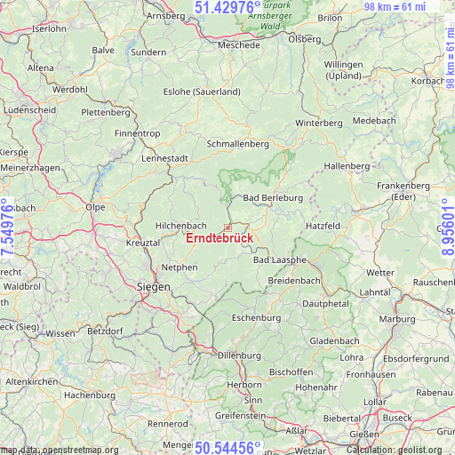
Erndtebrück GPS coordinates[2]
50° 59' 21.372" North, 8° 15' 10.368" East
| Map corner | latitude | longitude |
|---|---|---|
| Upper-left | 51.42976°, | 7.54976° |
| Center: | 50.98927°, | 8.25288° |
| Lower-right: | 50.54456°, | 8.95601° |
| Map W x H: | 98.4×98.4 km | = 61.1×61.1mi |
| max Lat: | 55.01917° ⇑42.1% North |
| Erndtebrück: | 50.98927° |
| min Lat: | ⇓57.9% South 47.40724° |
| min Long | Erndtebrück | max Long |
| 5.92978° | 8.25288° | 14.98853° |
| W 26.5%⇐ | ⇒73.5% E |
Elevation
Elevation of Erndtebrück is 490 m = 1608 ft, and this is 240.9 m = 790 ft above average elevation for this country.
| Max E: |
1256 m = 4121 ft | 12.4% |
| Erndtebrück | 490 m 1608 ft | |
| Avg. | 249.1 m = 817 ft | |
Min E: |
-5 m = -16 ft | 87.6% |
See also: Germany elevation on elevation.city.
Geographical zone
Erndtebrück is located in North temperate zone (between Tropic of Cancer and the Arctic Circle). Distance of this North polar circle is 1731.7 km =1076 mi to North.| Distance of | km | miles | from Erndtebrück |
|---|---|---|---|
| North Pole | 4337.6 | 2695.3 | to North |
| Arctic Circle | 1731.7 | 1076 | to North |
| Tropic Cancer | 3063.6 | 1903.6 | to South |
| Equator | 5669.5 | 3522.9 | to South |


Nearby cities:
15 places around Erndtebrück: (largest is in red/bold)
• Bad Berleburg
12 km =7.5 mi,  54°
54°
• Bad Fredeburg
22.6 km =14 mi,  10°
10°
• Bad Laasphe
13.7 km =8.5 mi,  118°
118°
• Bamenohl
27.1 km =16.8 mi,  316°
316°
• Biedenkopf
21.3 km =13.2 mi,  114°
114°
• Breidenbach
18.3 km =11.4 mi,  128°
128°
• Hatzfeld
20.5 km =12.7 mi,  88°
88°
• Hilchenbach
10 km =6.2 mi,  274°
274°
• Kirchhundem
15.7 km =9.8 mi,  313°
313°
• Kreuztal
18.7 km =11.6 mi,  262°
262°
• Lennestadt
19.3 km =12 mi, 317°
• Netphen
13.4 km =8.3 mi,  232°
232°
• Schmallenberg
18.5 km =11.5 mi, 6°
• Siegen
20.5 km =12.7 mi, 231°
• Wilnsdorf
22 km =13.7 mi,  209°
209°
Sources, notices
• [Note1] Compared only with cities in Germany existing in our database
• [Src1] Map data: © OpenStreetMap contributors (CC-BY-SA)
• [Src2] Other city data from geonames.org with taken over terms of usage.
• [Src3] Geographical zone / Annual Mean Temperature by Robert A. Rohde @ Wikipedia
