Breidenbach geodata
Breidenbach (Hesse) is a seat of a fourth-order administrative division; located in Germany in Europe/Berlin (GMT+2) time zone. With population of 6,866 people, there are 2213 cities with bigger population in this country. Compared to other cities in Germany, 55.8% of cities are located further ↓South; 71.5% of cities are located further →East and 65.8% of cities have lower elevation than Breidenbach. Note1
Administrative division(s):
- Level 1: Hesse
- Level 2: Regierungsbezirk Gießen
- Level 3: Landkreis Marburg-Biedenkopf
- Level 4: Breidenbach


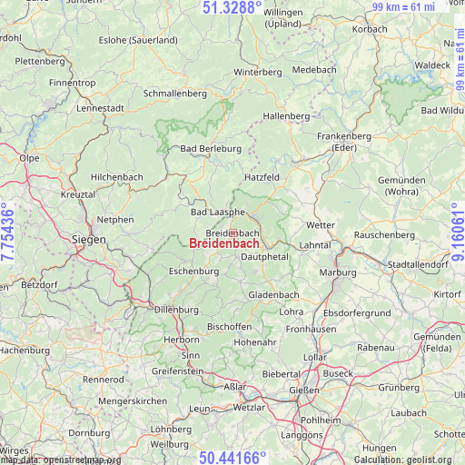
Breidenbach GPS coordinates[2]
50° 53' 14.424" North, 8° 27' 26.928" East
| Map corner | latitude | longitude |
|---|---|---|
| Upper-left | 51.3288°, | 7.75436° |
| Center: | 50.88734°, | 8.45748° |
| Lower-right: | 50.44166°, | 9.16061° |
| Map W x H: | 98.6×98.6 km | = 61.3×61.3mi |
| max Lat: | 55.01917° ⇑44.2% North |
| Breidenbach: | 50.88734° |
| min Lat: | ⇓55.8% South 47.40724° |
| min Long | Breidenbach | max Long |
| 5.92978° | 8.45748° | 14.98853° |
| W 28.5%⇐ | ⇒71.5% E |
Elevation
Elevation of Breidenbach is 327 m = 1073 ft, and this is 77.9 m = 256 ft above average elevation for this country.
| Max E: |
1256 m = 4121 ft | 34.2% |
| Breidenbach | 327 m 1073 ft | |
| Avg. | 249.1 m = 817 ft | |
Min E: |
-5 m = -16 ft | 65.8% |
See also: Germany elevation on elevation.city.
Geographical zone
Breidenbach is located in North temperate zone (between Tropic of Cancer and the Arctic Circle). Distance of this North polar circle is 1743 km =1083 mi to North.| Distance of | km | miles | from Breidenbach |
|---|---|---|---|
| North Pole | 4348.9 | 2702.3 | to North |
| Arctic Circle | 1743 | 1083 | to North |
| Tropic Cancer | 3052.2 | 1896.5 | to South |
| Equator | 5658.1 | 3515.8 | to South |


Nearby cities:
15 places around Breidenbach: (largest is in red/bold)
• Bad Berleburg
18.9 km =11.7 mi,  346°
346°
• Bad Endbach
15.6 km =9.7 mi,  168°
168°
• Bad Laasphe
5.4 km =3.4 mi,  335°
335°
• Battenberg
19.3 km =12 mi,  43°
43°
• Biedenkopf
5.7 km =3.5 mi,  62°
62°
• Bischoffen
20.8 km =12.9 mi,  181°
181°
• Dillenburg
20.2 km =12.6 mi,  216°
216°
• Erndtebrück
18.3 km =11.4 mi,  308°
308°
• Gladenbach
15.8 km =9.8 mi,  146°
146°
• Hatzfeld
13.3 km =8.3 mi,  27°
27°
• Lohra
21.1 km =13.1 mi,  144°
144°
• Mittenaar
21.5 km =13.4 mi,  194°
194°
• Münchhausen
20 km =12.4 mi,  65°
65°
• Siegbach
16.7 km =10.4 mi, 189°
• Wetter
18.7 km =11.6 mi,  84°
84°
Sources, notices
• [Note1] Compared only with cities in Germany existing in our database
• [Src1] Map data: © OpenStreetMap contributors (CC-BY-SA)
• [Src2] Other city data from geonames.org with taken over terms of usage.
• [Src3] Geographical zone / Annual Mean Temperature by Robert A. Rohde @ Wikipedia
