Bad Berleburg geodata
Bad Berleburg (North Rhine-Westphalia) is a populated place; located in Germany in Europe/Berlin (GMT+2) time zone. With population of 20,757 people, there are 741 cities with bigger population in this country. Compared to other cities in Germany, 59% of cities are located further ↓South; 72% of cities are located further →East and 78.2% of cities have lower elevation than Bad Berleburg. Note1
Administrative division(s):
- Level 1: North Rhine-Westphalia
- Level 2: Regierungsbezirk Arnsberg
- Level 3: Kreis Siegen-Wittgenstein
- Level 4: Bad Berleburg


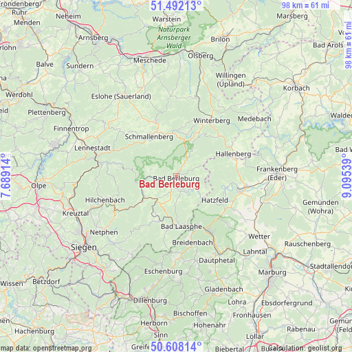
Bad Berleburg GPS coordinates[2]
51° 3' 8.064" North, 8° 23' 32.172" East
| Map corner | latitude | longitude |
|---|---|---|
| Upper-left | 51.49213°, | 7.68914° |
| Center: | 51.05224°, | 8.39227° |
| Lower-right: | 50.60814°, | 9.09539° |
| Map W x H: | 98.3×98.3 km | = 61.1×61.1mi |
| max Lat: | 55.01917° ⇑41% North |
| Bad Berleburg: | 51.05224° |
| min Lat: | ⇓59% South 47.40724° |
| min Long | Bad Berleburg | max Long |
| 5.92978° | 8.39227° | 14.98853° |
| W 28%⇐ | ⇒72% E |
Elevation
Elevation of Bad Berleburg is 420 m = 1378 ft, and this is 170.9 m = 561 ft above average elevation for this country.
| Max E: |
1256 m = 4121 ft | 21.8% |
| Bad Berleburg | 420 m 1378 ft | |
| Avg. | 249.1 m = 817 ft | |
Min E: |
-5 m = -16 ft | 78.2% |
See also: Germany elevation on elevation.city.
Geographical zone
Bad Berleburg is located in North temperate zone (between Tropic of Cancer and the Arctic Circle). Distance of this North polar circle is 1724.7 km =1071.7 mi to North.| Distance of | km | miles | from Bad Berleburg |
|---|---|---|---|
| North Pole | 4330.6 | 2690.9 | to North |
| Arctic Circle | 1724.7 | 1071.7 | to North |
| Tropic Cancer | 3070.6 | 1908 | to South |
| Equator | 5676.5 | 3527.2 | to South |


Nearby cities:
15 places around Bad Berleburg: (largest is in red/bold)
• Allendorf
19.7 km =12.2 mi,  97°
97°
• Bad Fredeburg
16.3 km =10.1 mi,  339°
339°
• Bad Laasphe
13.6 km =8.5 mi,  170°
170°
• Battenberg
18.2 km =11.3 mi, 103°
• Biedenkopf
18.4 km =11.4 mi,  148°
148°
• Breidenbach
18.9 km =11.7 mi, 166°
• Bromskirchen
17 km =10.6 mi,  74°
74°
• Erndtebrück
12 km =7.5 mi,  234°
234°
• Hallenberg
17.2 km =10.7 mi, 67°
• Hatzfeld
12.6 km =7.8 mi,  121°
121°
• Hilchenbach
20.6 km =12.8 mi,  252°
252°
• Kirchhundem
21.5 km =13.4 mi,  279°
279°
• Schmallenberg
13.6 km =8.5 mi,  326°
326°
• Silbach
20.7 km =12.9 mi,  17°
17°
• Winterberg
18.5 km =11.5 mi,  32°
32°
Sources, notices
• [Note1] Compared only with cities in Germany existing in our database
• [Src1] Map data: © OpenStreetMap contributors (CC-BY-SA)
• [Src2] Other city data from geonames.org with taken over terms of usage.
• [Src3] Geographical zone / Annual Mean Temperature by Robert A. Rohde @ Wikipedia
