Karlsruhe geodata
Karlsruhe (Baden-Württemberg) is a seat of a second-order administrative division; located in Germany in Europe/Berlin (GMT+2) time zone. With population of 283,799 people, there are 23 cities with bigger population in this country. Compared to other cities in Germany, 82.9% of cities are located further ↑North; 71.9% of cities are located further →East and 65.4% of cities have higher elevation than Karlsruhe. Note1
Administrative division(s):
- Level 1: Baden-Württemberg
- Level 2: Karlsruhe Region
- Level 3: Stadtkreis Karlsruhe
- Level 4: Karlsruhe


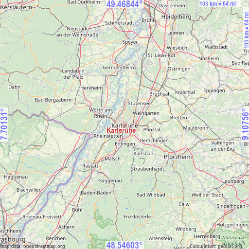
Karlsruhe GPS coordinates[2]
49° 0' 33.732" North, 8° 24' 15.984" East
| Map corner | latitude | longitude |
|---|---|---|
| Upper-left | 49.46844°, | 7.70131° |
| Center: | 49.00937°, | 8.40444° |
| Lower-right: | 48.54603°, | 9.10756° |
| Map W x H: | 102.6×102.6 km | = 63.8×63.8mi |
| max Lat: | 55.01917° ⇑82.9% North |
| Karlsruhe: | 49.00937° |
| min Lat: | ⇓17.1% South 47.40724° |
| min Long | Karlsruhe | max Long |
| 5.92978° | 8.40444° | 14.98853° |
| W 28.1%⇐ | ⇒71.9% E |
Elevation
Elevation of Karlsruhe is 118 m = 387 ft, and this is 131.1 m = 430 ft below average elevation for this country.
| Max E: |
1256 m = 4121 ft | 65.4% |
| Avg. | 249.1 m = 817 ft | |
| Karlsruhe | 118 m = 387 ft | |
Min E: |
-5 m = -16 ft | 34.6% |
See also: Karlsruhe elevation on elevation.city.
Geographical zone
Karlsruhe is located in North temperate zone (between Tropic of Cancer and the Arctic Circle). Distance of this North polar circle is 1951.8 km =1212.8 mi to North.| Distance of | km | miles | from Karlsruhe |
|---|---|---|---|
| North Pole | 4557.7 | 2832 | to North |
| Arctic Circle | 1951.8 | 1212.8 | to North |
| Tropic Cancer | 2843.4 | 1766.8 | to South |
| Equator | 5449.3 | 3386 | to South |


Nearby cities:
15 places around Karlsruhe: (largest is in red/bold)
• Au am Rhein
14.1 km =8.8 mi,  242°
242°
• Durmersheim
13.1 km =8.1 mi,  229°
229°
• Eggenstein-Leopoldshafen
9 km =5.6 mi,  357°
357°
• Ettlingen
7.6 km =4.7 mi,  178°
178°
• Hagenbach
11.3 km =7 mi,  274°
274°
• Jockgrim
13.3 km =8.3 mi,  314°
314°
• Jöhlingen
12.6 km =7.8 mi,  78°
78°
• Leimersheim
13.5 km =8.4 mi,  341°
341°
• Linkenheim-Hochstetten
13.6 km =8.5 mi,  2°
2°
• Neuburg
11.7 km =7.3 mi,  259°
259°
• Neupotz
13.6 km =8.5 mi,  332°
332°
• Rheinstetten
8.4 km =5.2 mi, 237°
• Weingarten
10.2 km =6.3 mi,  60°
60°
• Wörth am Rhein
11.4 km =7.1 mi,  292°
292°
• Wössingen
14.8 km =9.2 mi,  88°
88°
Sources, notices
• [Note1] Compared only with cities in Germany existing in our database
• [Src1] Map data: © OpenStreetMap contributors (CC-BY-SA)
• [Src2] Other city data from geonames.org with taken over terms of usage.
• [Src3] Geographical zone / Annual Mean Temperature by Robert A. Rohde @ Wikipedia
