Kürnach geodata
Kürnach (Bavaria) is a seat of a fourth-order administrative division; located in Germany in Europe/Berlin (GMT+2) time zone. With population of 4,332 people, there are 3118 cities with bigger population in this country. Compared to other cities in Germany, 67.8% of cities are located further ↑North; 50.7% of cities are located further ←West and 56% of cities have lower elevation than Kürnach. Note1
Administrative division(s):
- Level 1: Bavaria
- Level 2: Regierungsbezirk Unterfranken
- Level 3: Landkreis Würzburg
- Level 4: Kürnach


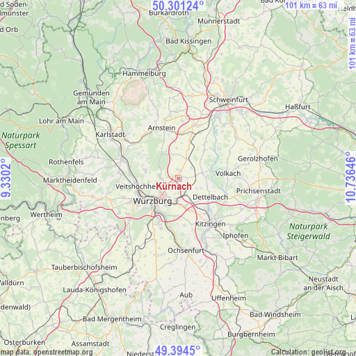
Kürnach GPS coordinates[2]
49° 51' 0" North, 10° 1' 59.988" East
| Map corner | latitude | longitude |
|---|---|---|
| Upper-left | 50.30124°, | 9.3302° |
| Center: | 49.85°, | 10.03333° |
| Lower-right: | 49.3945°, | 10.73646° |
| Map W x H: | 100.8×100.8 km | = 62.6×62.6mi |
| max Lat: | 55.01917° ⇑67.8% North |
| Kürnach: | 49.85° |
| min Lat: | ⇓32.2% South 47.40724° |
| min Long | Kürnach | max Long |
| 5.92978° | 10.03333° | 14.98853° |
| W 50.7%⇐ | ⇒49.3% E |
Elevation
Elevation of Kürnach is 266 m = 873 ft, and this is 16.9 m = 55 ft above average elevation for this country.
| Max E: |
1256 m = 4121 ft | 44% |
| Kürnach | 266 m 873 ft | |
| Avg. | 249.1 m = 817 ft | |
Min E: |
-5 m = -16 ft | 56% |
See also: Germany elevation on elevation.city.
Geographical zone
Kürnach is located in North temperate zone (between Tropic of Cancer and the Arctic Circle). Distance of this North polar circle is 1858.4 km =1154.8 mi to North.| Distance of | km | miles | from Kürnach |
|---|---|---|---|
| North Pole | 4464.3 | 2774 | to North |
| Arctic Circle | 1858.4 | 1154.8 | to North |
| Tropic Cancer | 2936.9 | 1824.9 | to South |
| Equator | 5542.8 | 3444.1 | to South |


Nearby cities:
15 places around Kürnach: (largest is in red/bold)
• Bergtheim
6.1 km =3.8 mi,  23°
23°
• Biebelried
9.9 km =6.2 mi,  158°
158°
• Dettelbach
10.8 km =6.7 mi,  118°
118°
• Estenfeld
3.1 km =1.9 mi,  220°
220°
• Gadheim
9.2 km =5.7 mi,  267°
267°
• Gerbrunn
8.8 km =5.5 mi,  198°
198°
• Güntersleben
9.5 km =5.9 mi,  283°
283°
• Oberpleichfeld
4.9 km =3 mi,  51°
51°
• Prosselsheim
6.8 km =4.2 mi,  77°
77°
• Randersacker
10.6 km =6.6 mi, 199°
• Rimpar
5.5 km =3.4 mi, 278°
• Rottendorf
6.4 km =4 mi,  184°
184°
• Theilheim
10.7 km =6.6 mi, 181°
• Unterpleichfeld
2.2 km =1.4 mi, 20°
• Würzburg
8.6 km =5.3 mi, 223°
Sources, notices
• [Note1] Compared only with cities in Germany existing in our database
• [Src1] Map data: © OpenStreetMap contributors (CC-BY-SA)
• [Src2] Other city data from geonames.org with taken over terms of usage.
• [Src3] Geographical zone / Annual Mean Temperature by Robert A. Rohde @ Wikipedia
