Sparneck geodata
Sparneck (Bavaria) is a populated place; located in Germany in Europe/Berlin (GMT+2) time zone. With population of 1,802 people, there are 5346 cities with bigger population in this country. Compared to other cities in Germany, 59.8% of cities are located further ↑North; 79.4% of cities are located further ←West and 93.3% of cities have lower elevation than Sparneck. Note1
Administrative division(s):
- Level 1: Bavaria
- Level 2: Upper Franconia
- Level 3: Landkreis Hof
- Level 4: Sparneck, Markt


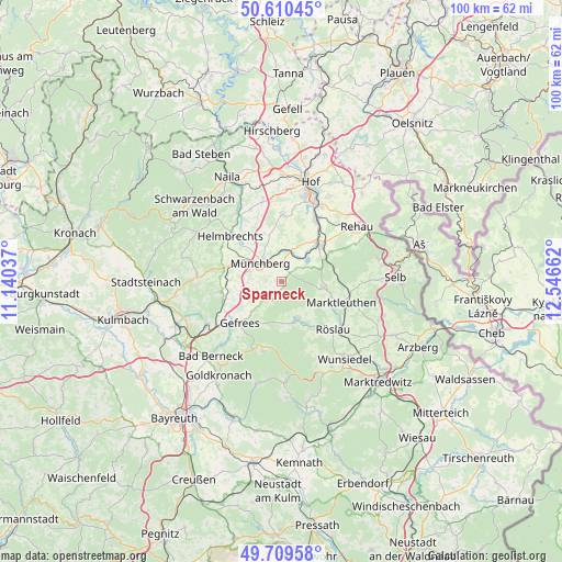
Sparneck GPS coordinates[2]
50° 9' 43.704" North, 11° 50' 36.564" East
| Map corner | latitude | longitude |
|---|---|---|
| Upper-left | 50.61045°, | 11.14037° |
| Center: | 50.16214°, | 11.84349° |
| Lower-right: | 49.70958°, | 12.54662° |
| Map W x H: | 100.2×100.2 km | = 62.3×62.3mi |
| max Lat: | 55.01917° ⇑59.8% North |
| Sparneck: | 50.16214° |
| min Lat: | ⇓40.2% South 47.40724° |
| min Long | Sparneck | max Long |
| 5.92978° | 11.84349° | 14.98853° |
| W 79.4%⇐ | ⇒20.6% E |
Elevation
Elevation of Sparneck is 563 m = 1847 ft, and this is 313.9 m = 1030 ft above average elevation for this country.
| Max E: |
1256 m = 4121 ft | 6.7% |
| Sparneck | 563 m 1847 ft | |
| Avg. | 249.1 m = 817 ft | |
Min E: |
-5 m = -16 ft | 93.3% |
See also: Germany elevation on elevation.city.
Geographical zone
Sparneck is located in North temperate zone (between Tropic of Cancer and the Arctic Circle). Distance of this North polar circle is 1823.7 km =1133.2 mi to North.| Distance of | km | miles | from Sparneck |
|---|---|---|---|
| North Pole | 4429.6 | 2752.4 | to North |
| Arctic Circle | 1823.7 | 1133.2 | to North |
| Tropic Cancer | 2971.6 | 1846.5 | to South |
| Equator | 5577.5 | 3465.7 | to South |


Nearby cities:
15 places around Sparneck: (largest is in red/bold)
• Bischofsgrün
12.7 km =7.9 mi,  194°
194°
• Gefrees
10.6 km =6.6 mi,  225°
225°
• Grub
9 km =5.6 mi,  137°
137°
• Helmbrechts
12.2 km =7.6 mi,  311°
311°
• Kirchenlamitz
7.6 km =4.7 mi,  98°
98°
• Konradsreuth
11.6 km =7.2 mi,  2°
2°
• Marktleuthen
11.9 km =7.4 mi,  107°
107°
• Münchberg
5 km =3.1 mi, 307°
• Oberhaid
4.8 km =3 mi,  214°
214°
• Oberkotzau
12.9 km =8 mi,  30°
30°
• Schwarzenbach an der Saale
9.4 km =5.8 mi,  44°
44°
• Stammbach
11 km =6.8 mi,  260°
260°
• Weißdorf
2.4 km =1.5 mi,  11°
11°
• Weißenstadt
7.4 km =4.6 mi,  154°
154°
• Zell im Fichtelgebirge
3.3 km =2.1 mi, 206°
Sources, notices
• [Note1] Compared only with cities in Germany existing in our database
• [Src1] Map data: © OpenStreetMap contributors (CC-BY-SA)
• [Src2] Other city data from geonames.org with taken over terms of usage.
• [Src3] Geographical zone / Annual Mean Temperature by Robert A. Rohde @ Wikipedia
