Weißdorf geodata
Weißdorf (Bavaria) is a seat of a fourth-order administrative division; located in Germany in Europe/Berlin (GMT+2) time zone. With population of 1,382 people, there are 6114 cities with bigger population in this country. Compared to other cities in Germany, 59.4% of cities are located further ↑North; 79.5% of cities are located further ←West and 92.5% of cities have lower elevation than Weißdorf. Note1
Administrative division(s):
- Level 1: Bavaria
- Level 2: Upper Franconia
- Level 3: Landkreis Hof
- Level 4: Weißdorf


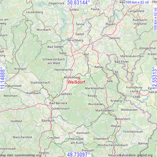
Weißdorf GPS coordinates[2]
50° 10' 59.988" North, 11° 51' 0" East
| Map corner | latitude | longitude |
|---|---|---|
| Upper-left | 50.63144°, | 11.14688° |
| Center: | 50.18333°, | 11.85° |
| Lower-right: | 49.73097°, | 12.55313° |
| Map W x H: | 100.1×100.1 km | = 62.2×62.2mi |
| max Lat: | 55.01917° ⇑59.4% North |
| Weißdorf: | 50.18333° |
| min Lat: | ⇓40.6% South 47.40724° |
| min Long | Weißdorf | max Long |
| 5.92978° | 11.85° | 14.98853° |
| W 79.5%⇐ | ⇒20.5% E |
Elevation
Elevation of Weißdorf is 551 m = 1808 ft, and this is 301.9 m = 990 ft above average elevation for this country.
| Max E: |
1256 m = 4121 ft | 7.5% |
| Weißdorf | 551 m 1808 ft | |
| Avg. | 249.1 m = 817 ft | |
Min E: |
-5 m = -16 ft | 92.5% |
See also: Germany elevation on elevation.city.
Geographical zone
Weißdorf is located in North temperate zone (between Tropic of Cancer and the Arctic Circle). Distance of this North polar circle is 1821.3 km =1131.7 mi to North.| Distance of | km | miles | from Weißdorf |
|---|---|---|---|
| North Pole | 4427.2 | 2750.9 | to North |
| Arctic Circle | 1821.3 | 1131.7 | to North |
| Tropic Cancer | 2973.9 | 1847.9 | to South |
| Equator | 5579.9 | 3467.2 | to South |


Nearby cities:
15 places around Weißdorf: (largest is in red/bold)
• Gefrees
12.6 km =7.8 mi,  219°
219°
• Grub
10.6 km =6.6 mi,  147°
147°
• Helmbrechts
11.2 km =7 mi,  301°
301°
• Kirchenlamitz
7.8 km =4.8 mi,  116°
116°
• Konradsreuth
9.3 km =5.8 mi,  0°
0°
• Marktleuthen
12.4 km =7.7 mi, 118°
• Münchberg
4.5 km =2.8 mi,  278°
278°
• Oberhaid
7.1 km =4.4 mi,  206°
206°
• Oberkotzau
10.7 km =6.6 mi,  34°
34°
• Schauenstein
13.1 km =8.1 mi,  323°
323°
• Schwarzenbach an der Saale
7.5 km =4.7 mi,  54°
54°
• Sparneck
2.4 km =1.5 mi,  191°
191°
• Stammbach
12.1 km =7.5 mi,  249°
249°
• Weißenstadt
9.4 km =5.8 mi,  163°
163°
• Zell im Fichtelgebirge
5.7 km =3.5 mi,  200°
200°
Sources, notices
• [Note1] Compared only with cities in Germany existing in our database
• [Src1] Map data: © OpenStreetMap contributors (CC-BY-SA)
• [Src2] Other city data from geonames.org with taken over terms of usage.
• [Src3] Geographical zone / Annual Mean Temperature by Robert A. Rohde @ Wikipedia
