Großschirma geodata
Großschirma (Saxony) is a populated place; located in Germany in Europe/Berlin (GMT+2) time zone. With population of 6,179 people, there are 2407 cities with bigger population in this country. Compared to other cities in Germany, 57.4% of cities are located further ↓South; 94.2% of cities are located further ←West and 71.4% of cities have lower elevation than Großschirma. Note1


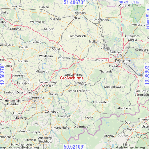
Großschirma GPS coordinates[2]
50° 57' 57.672" North, 13° 17' 9.24" East
| Map corner | latitude | longitude |
|---|---|---|
| Upper-left | 51.40673°, | 12.58278° |
| Center: | 50.96602°, | 13.2859° |
| Lower-right: | 50.52109°, | 13.98903° |
| Map W x H: | 98.5×98.5 km | = 61.2×61.2mi |
| max Lat: | 55.01917° ⇑42.6% North |
| Großschirma: | 50.96602° |
| min Lat: | ⇓57.4% South 47.40724° |
| min Long | Großschirma | max Long |
| 5.92978° | 13.2859° | 14.98853° |
| W 94.2%⇐ | ⇒5.8% E |
Elevation
Elevation of Großschirma is 369 m = 1211 ft, and this is 119.9 m = 393 ft above average elevation for this country.
| Max E: |
1256 m = 4121 ft | 28.6% |
| Großschirma | 369 m 1211 ft | |
| Avg. | 249.1 m = 817 ft | |
Min E: |
-5 m = -16 ft | 71.4% |
See also: Germany elevation on elevation.city.
Geographical zone
Großschirma is located in North temperate zone (between Tropic of Cancer and the Arctic Circle). Distance of this North polar circle is 1734.3 km =1077.6 mi to North.| Distance of | km | miles | from Großschirma |
|---|---|---|---|
| North Pole | 4340.2 | 2696.9 | to North |
| Arctic Circle | 1734.3 | 1077.6 | to North |
| Tropic Cancer | 3061 | 1902 | to South |
| Equator | 5666.9 | 3521.2 | to South |


Nearby cities:
15 places around Großschirma: (largest is in red/bold)
• Brand-Erbisdorf
11.4 km =7.1 mi,  166°
166°
• Falkenau
17 km =10.6 mi,  223°
223°
• Frankenstein
9 km =5.6 mi, 216°
• Freiberg
7.2 km =4.5 mi,  148°
148°
• Gahlenz
16.5 km =10.3 mi,  198°
198°
• Hainichen
11.4 km =7.1 mi,  272°
272°
• Halsbrücke
4.8 km =3 mi,  111°
111°
• Niederschöna
9.3 km =5.8 mi,  89°
89°
• Niederstriegis
16.1 km =10 mi,  323°
323°
• Nossen
10.3 km =6.4 mi,  4°
4°
• Oberschöna
7.9 km =4.9 mi, 196°
• Oederan
14.2 km =8.8 mi,  214°
214°
• Reinsberg
7.3 km =4.5 mi,  49°
49°
• Rossau
15.8 km =9.8 mi,  283°
283°
• Roßwein
13.2 km =8.2 mi,  327°
327°
Sources, notices
• [Note1] Compared only with cities in Germany existing in our database
• [Src1] Map data: © OpenStreetMap contributors (CC-BY-SA)
• [Src2] Other city data from geonames.org with taken over terms of usage.
• [Src3] Geographical zone / Annual Mean Temperature by Robert A. Rohde @ Wikipedia
