Hainichen geodata
Hainichen (Saxony) is a populated place; located in Germany in Europe/Berlin (GMT+2) time zone. With population of 9,511 people, there are 1702 cities with bigger population in this country. Compared to other cities in Germany, 57.6% of cities are located further ↓South; 93.2% of cities are located further ←West and 63.4% of cities have lower elevation than Hainichen. Note1


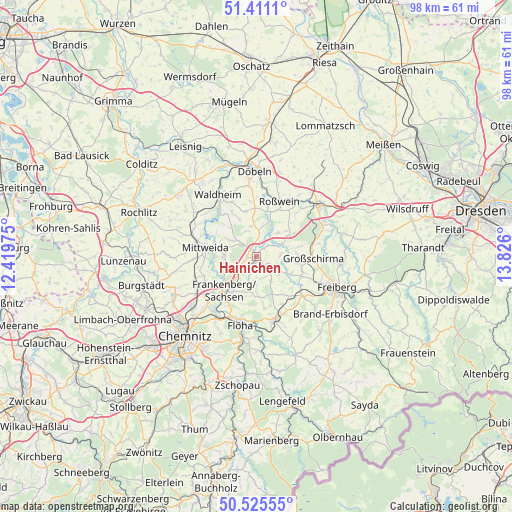
Hainichen GPS coordinates[2]
50° 58' 13.584" North, 13° 7' 22.332" East
| Map corner | latitude | longitude |
|---|---|---|
| Upper-left | 51.4111°, | 12.41975° |
| Center: | 50.97044°, | 13.12287° |
| Lower-right: | 50.52555°, | 13.826° |
| Map W x H: | 98.5×98.5 km | = 61.2×61.2mi |
| max Lat: | 55.01917° ⇑42.4% North |
| Hainichen: | 50.97044° |
| min Lat: | ⇓57.6% South 47.40724° |
| min Long | Hainichen | max Long |
| 5.92978° | 13.12287° | 14.98853° |
| W 93.2%⇐ | ⇒6.8% E |
Elevation
Elevation of Hainichen is 311 m = 1020 ft, and this is 61.9 m = 203 ft above average elevation for this country.
| Max E: |
1256 m = 4121 ft | 36.6% |
| Hainichen | 311 m 1020 ft | |
| Avg. | 249.1 m = 817 ft | |
Min E: |
-5 m = -16 ft | 63.4% |
See also: Germany elevation on elevation.city.
Geographical zone
Hainichen is located in North temperate zone (between Tropic of Cancer and the Arctic Circle). Distance of this North polar circle is 1733.8 km =1077.3 mi to North.| Distance of | km | miles | from Hainichen |
|---|---|---|---|
| North Pole | 4339.7 | 2696.6 | to North |
| Arctic Circle | 1733.8 | 1077.3 | to North |
| Tropic Cancer | 3061.5 | 1902.3 | to South |
| Equator | 5667.4 | 3521.6 | to South |


Nearby cities:
15 places around Hainichen: (largest is in red/bold)
• Altmittweida
12.1 km =7.5 mi,  268°
268°
• Erlau
13.1 km =8.1 mi,  289°
289°
• Falkenau
12.8 km =8 mi,  181°
181°
• Flöha
13.2 km =8.2 mi,  195°
195°
• Frankenberg
8.6 km =5.3 mi,  222°
222°
• Frankenstein
9.8 km =6.1 mi,  142°
142°
• Großschirma
11.4 km =7.1 mi,  92°
92°
• Kriebstein
11.6 km =7.2 mi,  319°
319°
• Mittweida
10.5 km =6.5 mi,  279°
279°
• Niederstriegis
12.6 km =7.8 mi,  8°
8°
• Oberschöna
12.2 km =7.6 mi,  131°
131°
• Oederan
12.7 km =7.9 mi,  164°
164°
• Rossau
5.1 km =3.2 mi,  309°
309°
• Roßwein
11.4 km =7.1 mi,  21°
21°
• Waldheim
13.5 km =8.4 mi,  327°
327°
Sources, notices
• [Note1] Compared only with cities in Germany existing in our database
• [Src1] Map data: © OpenStreetMap contributors (CC-BY-SA)
• [Src2] Other city data from geonames.org with taken over terms of usage.
• [Src3] Geographical zone / Annual Mean Temperature by Robert A. Rohde @ Wikipedia
