Freiberg geodata
Freiberg (Saxony) is a seat of a third-order administrative division; located in Germany in Europe/Berlin (GMT+2) time zone. With population of 43,670 people, there are 277 cities with bigger population in this country. Compared to other cities in Germany, 56.3% of cities are located further ↓South; 94.6% of cities are located further ←West and 77% of cities have lower elevation than Freiberg. Note1


Freiberg GPS coordinates[2]
50° 54' 39.204" North, 13° 20' 19.716" East
| Map corner | latitude | longitude |
|---|---|---|
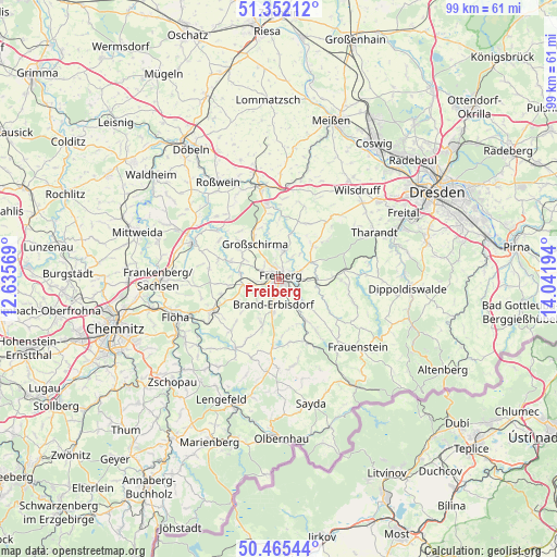
| Upper-left | 51.35212°, | 12.63569° |
| Center: | 50.91089°, | 13.33881° |
| Lower-right: | 50.46544°, | 14.04194° |
| Map W x H: | 98.6×98.6 km | = 61.3×61.3mi |
| max Lat: | 55.01917° ⇑43.7% North |
| Freiberg: | 50.91089° |
| min Lat: | ⇓56.3% South 47.40724° |
| min Long | Freiberg | max Long |
| 5.92978° | 13.33881° | 14.98853° |
| W 94.6%⇐ | ⇒5.4% E |
Elevation
Elevation of Freiberg is 412 m = 1352 ft, and this is 162.9 m = 534 ft above average elevation for this country.
| Max E: |
1256 m = 4121 ft | 23% |
| Freiberg | 412 m 1352 ft | |
| Avg. | 249.1 m = 817 ft | |
Min E: |
-5 m = -16 ft | 77% |
See also: Freiberg elevation on elevation.city.
Geographical zone
Freiberg is located in North temperate zone (between Tropic of Cancer and the Arctic Circle). Distance of this North polar circle is 1740.4 km =1081.4 mi to North.| Distance of | km | miles | from Freiberg |
|---|---|---|---|
| North Pole | 4346.3 | 2700.7 | to North |
| Arctic Circle | 1740.4 | 1081.4 | to North |
| Tropic Cancer | 3054.8 | 1898.2 | to South |
| Equator | 5660.8 | 3517.5 | to South |


Nearby cities:
15 places around Freiberg: (largest is in red/bold)
• Brand-Erbisdorf
5.1 km =3.2 mi,  192°
192°
• Eppendorf
14.4 km =8.9 mi,  210°
210°
• Frankenstein
9.1 km =5.7 mi,  262°
262°
• Gahlenz
13 km =8.1 mi,  223°
223°
• Großhartmannsdorf
12.3 km =7.6 mi,  181°
181°
• Großschirma
7.2 km =4.5 mi,  328°
328°
• Halsbrücke
4.4 km =2.7 mi,  10°
10°
• Lichtenberg
10.4 km =6.5 mi,  144°
144°
• Mulda
12.6 km =7.8 mi,  155°
155°
• Niederschöna
8.4 km =5.2 mi,  42°
42°
• Obercunnersdorf
15.5 km =9.6 mi,  87°
87°
• Oberschöna
6.1 km =3.8 mi, 256°
• Oederan
13 km =8.1 mi,  244°
244°
• Pretzschendorf
13.7 km =8.5 mi,  107°
107°
• Reinsberg
11 km =6.8 mi, 9°
Sources, notices
• [Note1] Compared only with cities in Germany existing in our database
• [Src1] Map data: © OpenStreetMap contributors (CC-BY-SA)
• [Src2] Other city data from geonames.org with taken over terms of usage.
• [Src3] Geographical zone / Annual Mean Temperature by Robert A. Rohde @ Wikipedia
