Ruhwinkel geodata
Ruhwinkel (Schleswig-Holstein) is a seat of a fourth-order administrative division; located in Germany in Europe/Berlin (GMT+2) time zone. With population of 1,069 people, there are 6939 cities with bigger population in this country. Compared to other cities in Germany, 93.9% of cities are located further ↓South; 53.6% of cities are located further ←West and 84.5% of cities have higher elevation than Ruhwinkel. Note1


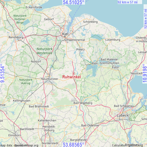
Ruhwinkel GPS coordinates[2]
54° 6' 0" North, 10° 13' 0.012" East
| Map corner | latitude | longitude |
|---|---|---|
| Upper-left | 54.51025°, | 9.51354° |
| Center: | 54.1°, | 10.21667° |
| Lower-right: | 53.68565°, | 10.9198° |
| Map W x H: | 91.7×91.7 km | = 57×57mi |
| max Lat: | 55.01917° ⇑6.1% North |
| Ruhwinkel: | 54.1° |
| min Lat: | ⇓93.9% South 47.40724° |
| min Long | Ruhwinkel | max Long |
| 5.92978° | 10.21667° | 14.98853° |
| W 53.6%⇐ | ⇒46.4% E |
Elevation
Elevation of Ruhwinkel is 36 m = 118 ft, and this is 213.1 m = 699 ft below average elevation for this country.
| Max E: |
1256 m = 4121 ft | 84.5% |
| Avg. | 249.1 m = 817 ft | |
| Ruhwinkel | 36 m = 118 ft | |
Min E: |
-5 m = -16 ft | 15.5% |
See also: Germany elevation on elevation.city.
Geographical zone
Ruhwinkel is located in North temperate zone (between Tropic of Cancer and the Arctic Circle). Distance of this North polar circle is 1385.8 km =861.1 mi to North.| Distance of | km | miles | from Ruhwinkel |
|---|---|---|---|
| North Pole | 3991.7 | 2480.3 | to North |
| Arctic Circle | 1385.8 | 861.1 | to North |
| Tropic Cancer | 3409.4 | 2118.5 | to South |
| Equator | 6015.4 | 3737.8 | to South |


Nearby cities:
15 places around Ruhwinkel: (largest is in red/bold)
• Belau
2.7 km =1.7 mi,  94°
94°
• Bornhöved
3.9 km =2.4 mi,  163°
163°
• Damsdorf
7.5 km =4.7 mi,  119°
119°
• Dersau
7.9 km =4.9 mi,  75°
75°
• Gönnebek
5.8 km =3.6 mi,  192°
192°
• Kalübbe
4.7 km =2.9 mi,  66°
66°
• Nettelsee
8.6 km =5.3 mi,  349°
349°
• Rendswühren
2.9 km =1.8 mi,  229°
229°
• Schillsdorf
5.7 km =3.5 mi,  288°
288°
• Schmalensee
4 km =2.5 mi, 118°
• Stocksee
8.2 km =5.1 mi,  97°
97°
• Stolpe
3.7 km =2.3 mi,  0°
0°
• Tarbek
6.4 km =4 mi,  149°
149°
• Trappenkamp
6.7 km =4.2 mi,  180°
180°
• Wankendorf
1.5 km =0.9 mi,  331°
331°
Sources, notices
• [Note1] Compared only with cities in Germany existing in our database
• [Src1] Map data: © OpenStreetMap contributors (CC-BY-SA)
• [Src2] Other city data from geonames.org with taken over terms of usage.
• [Src3] Geographical zone / Annual Mean Temperature by Robert A. Rohde @ Wikipedia
