Trappenkamp geodata
Trappenkamp (Schleswig-Holstein) is a seat of a fourth-order administrative division; located in Germany in Europe/Berlin (GMT+2) time zone. With population of 5,113 people, there are 2783 cities with bigger population in this country. Compared to other cities in Germany, 93.2% of cities are located further ↓South; 53.6% of cities are located further ←West and 78.9% of cities have higher elevation than Trappenkamp. Note1
Administrative division(s):
- Level 1: Schleswig-Holstein
- Level 3: Kreis Segeberg
- Level 4: Trappenkamp


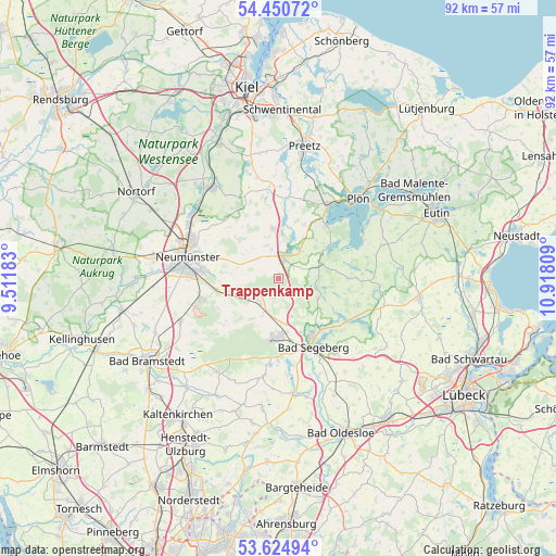
Trappenkamp GPS coordinates[2]
54° 2' 23.568" North, 10° 12' 53.856" East
| Map corner | latitude | longitude |
|---|---|---|
| Upper-left | 54.45072°, | 9.51183° |
| Center: | 54.03988°, | 10.21496° |
| Lower-right: | 53.62494°, | 10.91809° |
| Map W x H: | 91.8×91.8 km | = 57×57mi |
| max Lat: | 55.01917° ⇑6.8% North |
| Trappenkamp: | 54.03988° |
| min Lat: | ⇓93.2% South 47.40724° |
| min Long | Trappenkamp | max Long |
| 5.92978° | 10.21496° | 14.98853° |
| W 53.6%⇐ | ⇒46.4% E |
Elevation
Elevation of Trappenkamp is 50 m = 164 ft, and this is 199.1 m = 653 ft below average elevation for this country.
| Max E: |
1256 m = 4121 ft | 78.9% |
| Avg. | 249.1 m = 817 ft | |
| Trappenkamp | 50 m = 164 ft | |
Min E: |
-5 m = -16 ft | 21.1% |
See also: Germany elevation on elevation.city.
Geographical zone
Trappenkamp is located in North temperate zone (between Tropic of Cancer and the Arctic Circle). Distance of this North polar circle is 1392.5 km =865.3 mi to North.| Distance of | km | miles | from Trappenkamp |
|---|---|---|---|
| North Pole | 3998.4 | 2484.5 | to North |
| Arctic Circle | 1392.5 | 865.3 | to North |
| Tropic Cancer | 3402.8 | 2114.4 | to South |
| Equator | 6008.7 | 3733.6 | to South |


Nearby cities:
15 places around Trappenkamp: (largest is in red/bold)
• Belau
7.1 km =4.4 mi,  23°
23°
• Blunk
7.3 km =4.5 mi,  117°
117°
• Bornhöved
3.2 km =2 mi, 21°
• Daldorf
3.4 km =2.1 mi,  138°
138°
• Damsdorf
7.3 km =4.5 mi,  65°
65°
• Groß Kummerfeld
8.7 km =5.4 mi,  277°
277°
• Gönnebek
1.6 km =1 mi,  310°
310°
• Negernbötel
6.7 km =4.2 mi,  159°
159°
• Rendswühren
5.3 km =3.3 mi,  336°
336°
• Rickling
4.1 km =2.5 mi,  230°
230°
• Ruhwinkel
6.7 km =4.2 mi,  0°
0°
• Schmalensee
6 km =3.7 mi,  37°
37°
• Tarbek
3.6 km =2.2 mi, 71°
• Tensfeld
6.8 km =4.2 mi,  87°
87°
• Wankendorf
8.1 km =5 mi,  355°
355°
Sources, notices
• [Note1] Compared only with cities in Germany existing in our database
• [Src1] Map data: © OpenStreetMap contributors (CC-BY-SA)
• [Src2] Other city data from geonames.org with taken over terms of usage.
• [Src3] Geographical zone / Annual Mean Temperature by Robert A. Rohde @ Wikipedia
