Rendswühren geodata
Rendswühren (Schleswig-Holstein) is a seat of a fourth-order administrative division; located in Germany in Europe/Berlin (GMT+2) time zone. With population of 830 people, there are 7773 cities with bigger population in this country. Compared to other cities in Germany, 93.7% of cities are located further ↓South; 53.1% of cities are located further ←West and 81% of cities have higher elevation than Rendswühren. Note1


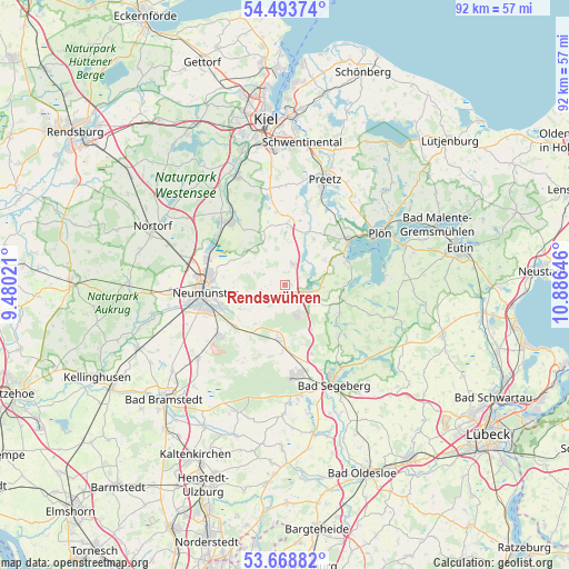
Rendswühren GPS coordinates[2]
54° 4' 59.988" North, 10° 10' 59.988" East
| Map corner | latitude | longitude |
|---|---|---|
| Upper-left | 54.49374°, | 9.48021° |
| Center: | 54.08333°, | 10.18333° |
| Lower-right: | 53.66882°, | 10.88646° |
| Map W x H: | 91.7×91.7 km | = 57×57mi |
| max Lat: | 55.01917° ⇑6.3% North |
| Rendswühren: | 54.08333° |
| min Lat: | ⇓93.7% South 47.40724° |
| min Long | Rendswühren | max Long |
| 5.92978° | 10.18333° | 14.98853° |
| W 53.1%⇐ | ⇒46.9% E |
Elevation
Elevation of Rendswühren is 44 m = 144 ft, and this is 205.1 m = 673 ft below average elevation for this country.
| Max E: |
1256 m = 4121 ft | 81% |
| Avg. | 249.1 m = 817 ft | |
| Rendswühren | 44 m = 144 ft | |
Min E: |
-5 m = -16 ft | 19% |
See also: Germany elevation on elevation.city.
Geographical zone
Rendswühren is located in North temperate zone (between Tropic of Cancer and the Arctic Circle). Distance of this North polar circle is 1387.7 km =862.3 mi to North.| Distance of | km | miles | from Rendswühren |
|---|---|---|---|
| North Pole | 3993.6 | 2481.5 | to North |
| Arctic Circle | 1387.7 | 862.3 | to North |
| Tropic Cancer | 3407.6 | 2117.4 | to South |
| Equator | 6013.5 | 3736.6 | to South |


Nearby cities:
15 places around Rendswühren: (largest is in red/bold)
• Belau
5.2 km =3.2 mi,  71°
71°
• Bornhöved
3.8 km =2.4 mi,  119°
119°
• Busdorf
7 km =4.3 mi,  288°
288°
• Bönebüttel
7.6 km =4.7 mi,  270°
270°
• Groß Kummerfeld
7.5 km =4.7 mi,  240°
240°
• Gönnebek
3.9 km =2.4 mi,  166°
166°
• Kalübbe
7.5 km =4.7 mi,  60°
60°
• Rickling
7.5 km =4.7 mi,  188°
188°
• Ruhwinkel
2.9 km =1.8 mi,  49°
49°
• Schillsdorf
4.9 km =3 mi,  318°
318°
• Schmalensee
5.7 km =3.5 mi,  90°
90°
• Stolpe
6 km =3.7 mi,  21°
21°
• Tarbek
6.6 km =4.1 mi, 124°
• Trappenkamp
5.3 km =3.3 mi,  156°
156°
• Wankendorf
3.5 km =2.2 mi, 24°
Sources, notices
• [Note1] Compared only with cities in Germany existing in our database
• [Src1] Map data: © OpenStreetMap contributors (CC-BY-SA)
• [Src2] Other city data from geonames.org with taken over terms of usage.
• [Src3] Geographical zone / Annual Mean Temperature by Robert A. Rohde @ Wikipedia
