Sperenberg geodata
Sperenberg (Brandenburg) is a populated place; located in Germany in Europe/Berlin (GMT+2) time zone. With population of 2,180 people, there are 4832 cities with bigger population in this country. Compared to other cities in Germany, 73.5% of cities are located further ↓South; 94.8% of cities are located further ←West and 78.7% of cities have higher elevation than Sperenberg. Note1
Administrative division(s):
- Level 1: Brandenburg
- Level 3: Landkreis Teltow-Fläming
- Level 4: Am Mellensee


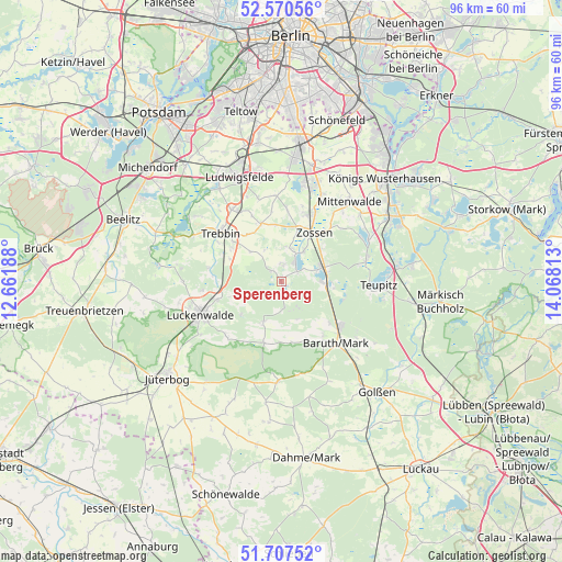
Sperenberg GPS coordinates[2]
52° 8' 28.068" North, 13° 21' 54" East
| Map corner | latitude | longitude |
|---|---|---|
| Upper-left | 52.57056°, | 12.66188° |
| Center: | 52.14113°, | 13.365° |
| Lower-right: | 51.70752°, | 14.06813° |
| Map W x H: | 96×96 km | = 59.7×59.7mi |
| max Lat: | 55.01917° ⇑26.5% North |
| Sperenberg: | 52.14113° |
| min Lat: | ⇓73.5% South 47.40724° |
| min Long | Sperenberg | max Long |
| 5.92978° | 13.365° | 14.98853° |
| W 94.8%⇐ | ⇒5.2% E |
Elevation
Elevation of Sperenberg is 51 m = 167 ft, and this is 198.1 m = 650 ft below average elevation for this country.
| Max E: |
1256 m = 4121 ft | 78.7% |
| Avg. | 249.1 m = 817 ft | |
| Sperenberg | 51 m = 167 ft | |
Min E: |
-5 m = -16 ft | 21.3% |
See also: Germany elevation on elevation.city.
Geographical zone
Sperenberg is located in North temperate zone (between Tropic of Cancer and the Arctic Circle). Distance of this North polar circle is 1603.6 km =996.4 mi to North.| Distance of | km | miles | from Sperenberg |
|---|---|---|---|
| North Pole | 4209.5 | 2615.7 | to North |
| Arctic Circle | 1603.6 | 996.4 | to North |
| Tropic Cancer | 3191.6 | 1983.2 | to South |
| Equator | 5797.6 | 3602.5 | to South |


Nearby cities:
15 places around Sperenberg: (largest is in red/bold)
• Am Mellensee
5.3 km =3.3 mi,  26°
26°
• Baruth
14.3 km =8.9 mi,  138°
138°
• Bestensee
21.6 km =13.4 mi,  59°
59°
• Golßen
24.8 km =15.4 mi, 139°
• Groß Köris
20.3 km =12.6 mi,  82°
82°
• Großbeeren
24.5 km =15.2 mi,  351°
351°
• Halbe
23 km =14.3 mi,  96°
96°
• Luckenwalde
14.6 km =9.1 mi,  247°
247°
• Ludwigsfelde
19.5 km =12.1 mi,  337°
337°
• Mittenwalde
17.8 km =11.1 mi,  41°
41°
• Rangsdorf
17.1 km =10.6 mi,  12°
12°
• Schwerin
18.3 km =11.4 mi,  86°
86°
• Teupitz
17.4 km =10.8 mi, 94°
• Trebbin
12.7 km =7.9 mi,  311°
311°
• Zossen
10.1 km =6.3 mi, 34°
Sources, notices
• [Note1] Compared only with cities in Germany existing in our database
• [Src1] Map data: © OpenStreetMap contributors (CC-BY-SA)
• [Src2] Other city data from geonames.org with taken over terms of usage.
• [Src3] Geographical zone / Annual Mean Temperature by Robert A. Rohde @ Wikipedia
