Großenkneten geodata
Großenkneten (Lower Saxony) is a seat of a fourth-order administrative division; located in Germany in Europe/Berlin (GMT+2) time zone. With population of 13,698 people, there are 1171 cities with bigger population in this country. Compared to other cities in Germany, 81.4% of cities are located further ↓South; 73.4% of cities are located further →East and 84.9% of cities have higher elevation than Großenkneten. Note1
Administrative division(s):
- Level 1: Lower Saxony
- Level 3: Landkreis Oldenburg
- Level 4: Großenkneten


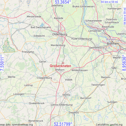
Großenkneten GPS coordinates[2]
52° 56' 37.572" North, 8° 15' 11.628" East
| Map corner | latitude | longitude |
|---|---|---|
| Upper-left | 53.3654°, | 7.55011° |
| Center: | 52.94377°, | 8.25323° |
| Lower-right: | 52.51799°, | 8.95636° |
| Map W x H: | 94.2×94.2 km | = 58.5×58.5mi |
| max Lat: | 55.01917° ⇑18.6% North |
| Großenkneten: | 52.94377° |
| min Lat: | ⇓81.4% South 47.40724° |
| min Long | Großenkneten | max Long |
| 5.92978° | 8.25323° | 14.98853° |
| W 26.6%⇐ | ⇒73.4% E |
Elevation
Elevation of Großenkneten is 35 m = 115 ft, and this is 214.1 m = 702 ft below average elevation for this country.
| Max E: |
1256 m = 4121 ft | 84.9% |
| Avg. | 249.1 m = 817 ft | |
| Großenkneten | 35 m = 115 ft | |
Min E: |
-5 m = -16 ft | 15.1% |
See also: Germany elevation on elevation.city.
Geographical zone
Großenkneten is located in North temperate zone (between Tropic of Cancer and the Arctic Circle). Distance of this North polar circle is 1514.4 km =941 mi to North.| Distance of | km | miles | from Großenkneten |
|---|---|---|---|
| North Pole | 4120.3 | 2560.2 | to North |
| Arctic Circle | 1514.4 | 941 | to North |
| Tropic Cancer | 3280.9 | 2038.7 | to South |
| Equator | 5886.8 | 3657.9 | to South |


Nearby cities:
15 places around Großenkneten: (largest is in red/bold)
• Bühren
15.5 km =9.6 mi,  188°
188°
• Cappeln
17.5 km =10.9 mi,  212°
212°
• Cloppenburg
17.6 km =10.9 mi,  232°
232°
• Colnrade
19.7 km =12.2 mi,  128°
128°
• Dötlingen
8.8 km =5.5 mi,  97°
97°
• Emstek
14.1 km =8.8 mi, 209°
• Ganderkesee
21.2 km =13.2 mi,  62°
62°
• Garrel
15.9 km =9.9 mi,  272°
272°
• Goldenstedt
21 km =13 mi,  145°
145°
• Hatten
14.7 km =9.1 mi,  36°
36°
• Prinzhöfte
21 km =13 mi,  88°
88°
• Visbek
13 km =8.1 mi,  160°
160°
• Wardenburg
14.1 km =8.8 mi,  345°
345°
• Wildeshausen
13.3 km =8.3 mi,  114°
114°
• Winkelsett
20.6 km =12.8 mi, 114°
Sources, notices
• [Note1] Compared only with cities in Germany existing in our database
• [Src1] Map data: © OpenStreetMap contributors (CC-BY-SA)
• [Src2] Other city data from geonames.org with taken over terms of usage.
• [Src3] Geographical zone / Annual Mean Temperature by Robert A. Rohde @ Wikipedia
