Hatten geodata
Hatten (Lower Saxony) is a seat of a fourth-order administrative division; located in Germany in Europe/Berlin (GMT+2) time zone. With population of 13,499 people, there are 1187 cities with bigger population in this country. Compared to other cities in Germany, 82% of cities are located further ↓South; 72.1% of cities are located further →East and 87.3% of cities have higher elevation than Hatten. Note1


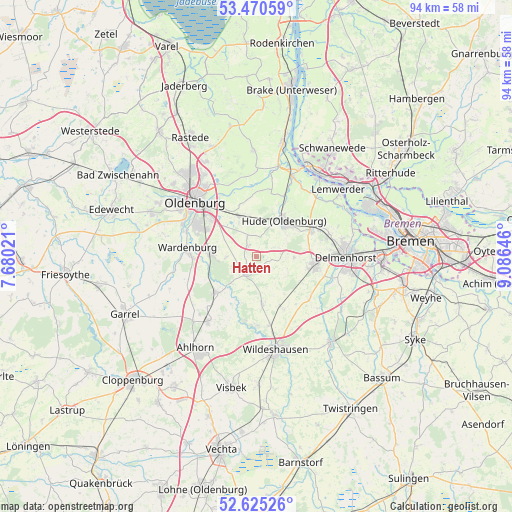
Hatten GPS coordinates[2]
53° 3' 0" North, 8° 22' 59.988" East
| Map corner | latitude | longitude |
|---|---|---|
| Upper-left | 53.47059°, | 7.68021° |
| Center: | 53.05°, | 8.38333° |
| Lower-right: | 52.62526°, | 9.08646° |
| Map W x H: | 94×94 km | = 58.4×58.4mi |
| max Lat: | 55.01917° ⇑18% North |
| Hatten: | 53.05° |
| min Lat: | ⇓82% South 47.40724° |
| min Long | Hatten | max Long |
| 5.92978° | 8.38333° | 14.98853° |
| W 27.9%⇐ | ⇒72.1% E |
Elevation
Elevation of Hatten is 29 m = 95 ft, and this is 220.1 m = 722 ft below average elevation for this country.
| Max E: |
1256 m = 4121 ft | 87.3% |
| Avg. | 249.1 m = 817 ft | |
| Hatten | 29 m = 95 ft | |
Min E: |
-5 m = -16 ft | 12.7% |
See also: Germany elevation on elevation.city.
Geographical zone
Hatten is located in North temperate zone (between Tropic of Cancer and the Arctic Circle). Distance of this North polar circle is 1502.6 km =933.7 mi to North.| Distance of | km | miles | from Hatten |
|---|---|---|---|
| North Pole | 4108.5 | 2552.9 | to North |
| Arctic Circle | 1502.6 | 933.7 | to North |
| Tropic Cancer | 3292.7 | 2046 | to South |
| Equator | 5898.6 | 3665.2 | to South |


Nearby cities:
15 places around Hatten: (largest is in red/bold)
• Delmenhorst
16.5 km =10.3 mi,  89°
89°
• Dötlingen
13 km =8.1 mi,  180°
180°
• Dünsen
22 km =13.7 mi,  128°
128°
• Elsfleth
21.4 km =13.3 mi,  13°
13°
• Ganderkesee
10.2 km =6.3 mi,  100°
100°
• Groß Ippener
18.2 km =11.3 mi,  120°
120°
• Großenkneten
14.7 km =9.1 mi,  216°
216°
• Harpstedt
20.9 km =13 mi,  138°
138°
• Hude
8.3 km =5.2 mi,  39°
39°
• Lemwerder
20.3 km =12.6 mi,  50°
50°
• Oldenburg
15.2 km =9.4 mi,  311°
311°
• Prinzhöfte
16.6 km =10.3 mi, 132°
• Vegesack
20.3 km =12.6 mi, 50°
• Wardenburg
12.4 km =7.7 mi,  278°
278°
• Wildeshausen
17.6 km =10.9 mi,  168°
168°
Sources, notices
• [Note1] Compared only with cities in Germany existing in our database
• [Src1] Map data: © OpenStreetMap contributors (CC-BY-SA)
• [Src2] Other city data from geonames.org with taken over terms of usage.
• [Src3] Geographical zone / Annual Mean Temperature by Robert A. Rohde @ Wikipedia
