Ganderkesee geodata
Ganderkesee (Lower Saxony) is a seat of a fourth-order administrative division; located in Germany in Europe/Berlin (GMT+2) time zone. With population of 31,141 people, there are 446 cities with bigger population in this country. Compared to other cities in Germany, 81.9% of cities are located further ↓South; 70.8% of cities are located further →East and 85.4% of cities have higher elevation than Ganderkesee. Note1


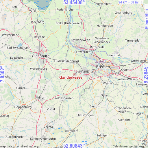
Ganderkesee GPS coordinates[2]
53° 1' 59.988" North, 8° 31' 59.988" East
| Map corner | latitude | longitude |
|---|---|---|
| Upper-left | 53.45408°, | 7.8302° |
| Center: | 53.03333°, | 8.53333° |
| Lower-right: | 52.60843°, | 9.23645° |
| Map W x H: | 94×94 km | = 58.4×58.4mi |
| max Lat: | 55.01917° ⇑18.1% North |
| Ganderkesee: | 53.03333° |
| min Lat: | ⇓81.9% South 47.40724° |
| min Long | Ganderkesee | max Long |
| 5.92978° | 8.53333° | 14.98853° |
| W 29.2%⇐ | ⇒70.8% E |
Elevation
Elevation of Ganderkesee is 34 m = 112 ft, and this is 215.1 m = 706 ft below average elevation for this country.
| Max E: |
1256 m = 4121 ft | 85.4% |
| Avg. | 249.1 m = 817 ft | |
| Ganderkesee | 34 m = 112 ft | |
Min E: |
-5 m = -16 ft | 14.6% |
See also: Germany elevation on elevation.city.
Geographical zone
Ganderkesee is located in North temperate zone (between Tropic of Cancer and the Arctic Circle). Distance of this North polar circle is 1504.4 km =934.8 mi to North.| Distance of | km | miles | from Ganderkesee |
|---|---|---|---|
| North Pole | 4110.3 | 2554 | to North |
| Arctic Circle | 1504.4 | 934.8 | to North |
| Tropic Cancer | 3290.8 | 2044.8 | to South |
| Equator | 5896.8 | 3664.1 | to South |


Nearby cities:
15 places around Ganderkesee: (largest is in red/bold)
• Burglesum
18 km =11.2 mi,  35°
35°
• Delmenhorst
6.8 km =4.2 mi,  73°
73°
• Dötlingen
15 km =9.3 mi,  222°
222°
• Dünsen
13.8 km =8.6 mi,  148°
148°
• Groß Ippener
9.3 km =5.8 mi,  143°
143°
• Harpstedt
14.3 km =8.9 mi,  164°
164°
• Hatten
10.2 km =6.3 mi,  280°
280°
• Hude
9.5 km =5.9 mi,  330°
330°
• Kirchseelte
13.7 km =8.5 mi,  132°
132°
• Lemwerder
15.8 km =9.8 mi,  20°
20°
• Prinzhöfte
9.5 km =5.9 mi,  166°
166°
• Stuhr
14.5 km =9 mi,  90°
90°
• Vegesack
15.8 km =9.8 mi, 20°
• Wildeshausen
16.8 km =10.4 mi,  203°
203°
• Winkelsett
18.5 km =11.5 mi,  180°
180°
Sources, notices
• [Note1] Compared only with cities in Germany existing in our database
• [Src1] Map data: © OpenStreetMap contributors (CC-BY-SA)
• [Src2] Other city data from geonames.org with taken over terms of usage.
• [Src3] Geographical zone / Annual Mean Temperature by Robert A. Rohde @ Wikipedia
