Colnrade geodata
Colnrade (Lower Saxony) is a seat of a fourth-order administrative division; located in Germany in Europe/Berlin (GMT+2) time zone. With population of 855 people, there are 7683 cities with bigger population in this country. Compared to other cities in Germany, 80.6% of cities are located further ↓South; 71.2% of cities are located further →East and 89.7% of cities have higher elevation than Colnrade. Note1


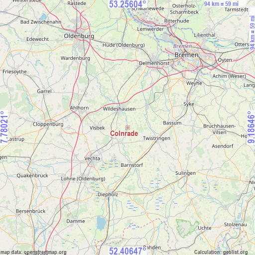
Colnrade GPS coordinates[2]
52° 49' 59.988" North, 8° 28' 59.988" East
| Map corner | latitude | longitude |
|---|---|---|
| Upper-left | 53.25604°, | 7.78021° |
| Center: | 52.83333°, | 8.48333° |
| Lower-right: | 52.40647°, | 9.18646° |
| Map W x H: | 94.5×94.5 km | = 58.7×58.7mi |
| max Lat: | 55.01917° ⇑19.4% North |
| Colnrade: | 52.83333° |
| min Lat: | ⇓80.6% South 47.40724° |
| min Long | Colnrade | max Long |
| 5.92978° | 8.48333° | 14.98853° |
| W 28.8%⇐ | ⇒71.2% E |
Elevation
Elevation of Colnrade is 22 m = 72 ft, and this is 227.1 m = 745 ft below average elevation for this country.
| Max E: |
1256 m = 4121 ft | 89.7% |
| Avg. | 249.1 m = 817 ft | |
| Colnrade | 22 m = 72 ft | |
Min E: |
-5 m = -16 ft | 10.3% |
See also: Germany elevation on elevation.city.
Geographical zone
Colnrade is located in North temperate zone (between Tropic of Cancer and the Arctic Circle). Distance of this North polar circle is 1526.7 km =948.6 mi to North.| Distance of | km | miles | from Colnrade |
|---|---|---|---|
| North Pole | 4132.5 | 2567.8 | to North |
| Arctic Circle | 1526.7 | 948.6 | to North |
| Tropic Cancer | 3268.6 | 2031 | to South |
| Equator | 5874.5 | 3650.2 | to South |


Nearby cities:
15 places around Colnrade: (largest is in red/bold)
• Barnstorf
13.8 km =8.6 mi,  174°
174°
• Bassum
16.5 km =10.3 mi,  83°
83°
• Beckeln
7.7 km =4.8 mi,  61°
61°
• Drentwede
11.4 km =7.1 mi,  151°
151°
• Dötlingen
13 km =8.1 mi,  328°
328°
• Dünsen
14.9 km =9.3 mi,  45°
45°
• Eydelstedt
16.2 km =10.1 mi,  164°
164°
• Goldenstedt
6.1 km =3.8 mi,  214°
214°
• Groß Ippener
17.3 km =10.7 mi,  31°
31°
• Harpstedt
11.1 km =6.9 mi,  40°
40°
• Prinzhöfte
14.1 km =8.8 mi,  23°
23°
• Twistringen
11.3 km =7 mi,  109°
109°
• Visbek
11.2 km =7 mi,  270°
270°
• Wildeshausen
7.6 km =4.7 mi, 333°
• Winkelsett
5 km =3.1 mi, 42°
Sources, notices
• [Note1] Compared only with cities in Germany existing in our database
• [Src1] Map data: © OpenStreetMap contributors (CC-BY-SA)
• [Src2] Other city data from geonames.org with taken over terms of usage.
• [Src3] Geographical zone / Annual Mean Temperature by Robert A. Rohde @ Wikipedia
