Teichwolframsdorf geodata
Teichwolframsdorf (Thuringia) is a populated place; located in Germany in Europe/Berlin (GMT+2) time zone. With population of 2,686 people, there are 4247 cities with bigger population in this country. Compared to other cities in Germany, 52.7% of cities are located further ↓South; 85.2% of cities are located further ←West and 63.8% of cities have lower elevation than Teichwolframsdorf. Note1
Administrative division(s):
- Level 1: Thuringia
- Level 3: Landkreis Greiz
- Level 4: Mohlsdorf-Teichwolframsdorf


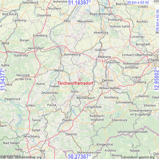
Teichwolframsdorf GPS coordinates[2]
50° 43' 15.348" North, 12° 14' 48.804" East
| Map corner | latitude | longitude |
|---|---|---|
| Upper-left | 51.16397°, | 11.54377° |
| Center: | 50.72093°, | 12.24689° |
| Lower-right: | 50.27367°, | 12.95002° |
| Map W x H: | 99×99 km | = 61.5×61.5mi |
| max Lat: | 55.01917° ⇑47.3% North |
| Teichwolframsdorf: | 50.72093° |
| min Lat: | ⇓52.7% South 47.40724° |
| min Long | Teichwolframsdo | max Long |
| 5.92978° | 12.24689° | 14.98853° |
| W 85.2%⇐ | ⇒14.8% E |
Elevation
Elevation of Teichwolframsdorf is 314 m = 1030 ft, and this is 64.9 m = 213 ft above average elevation for this country.
| Max E: |
1256 m = 4121 ft | 36.2% |
| Teichwolframsdorf | 314 m 1030 ft | |
| Avg. | 249.1 m = 817 ft | |
Min E: |
-5 m = -16 ft | 63.8% |
See also: Germany elevation on elevation.city.
Geographical zone
Teichwolframsdorf is located in North temperate zone (between Tropic of Cancer and the Arctic Circle). Distance of this North polar circle is 1761.5 km =1094.5 mi to North.| Distance of | km | miles | from Teichwolframsdorf |
|---|---|---|---|
| North Pole | 4367.4 | 2713.8 | to North |
| Arctic Circle | 1761.5 | 1094.5 | to North |
| Tropic Cancer | 3033.7 | 1885.1 | to South |
| Equator | 5639.6 | 3504.3 | to South |


Nearby cities:
15 places around Teichwolframsdorf: (largest is in red/bold)
• Berga
6.7 km =4.2 mi,  300°
300°
• Braunichswalde
9 km =5.6 mi,  346°
346°
• Endschütz
10.7 km =6.6 mi,  313°
313°
• Fraureuth
7.6 km =4.7 mi,  107°
107°
• Gauern
7.7 km =4.8 mi,  334°
334°
• Greiz
7.8 km =4.8 mi,  205°
205°
• Kühdorf
9.7 km =6 mi,  260°
260°
• Langenbernsdorf
6.8 km =4.2 mi,  55°
55°
• Leubnitz
7.7 km =4.8 mi,  88°
88°
• Mohlsdorf
5.8 km =3.6 mi,  167°
167°
• Neugernsdorf
8 km =5 mi,  266°
266°
• Neumark
10.2 km =6.3 mi,  131°
131°
• Seelingstädt
5.8 km =3.6 mi,  357°
357°
• Werdau
9.2 km =5.7 mi,  79°
79°
• Wildetaube
9.2 km =5.7 mi, 267°
Sources, notices
• [Note1] Compared only with cities in Germany existing in our database
• [Src1] Map data: © OpenStreetMap contributors (CC-BY-SA)
• [Src2] Other city data from geonames.org with taken over terms of usage.
• [Src3] Geographical zone / Annual Mean Temperature by Robert A. Rohde @ Wikipedia
