Grainau geodata
Grainau (Bavaria) is a seat of a fourth-order administrative division; located in Germany in Europe/Berlin (GMT+2) time zone. With population of 3,674 people, there are 3495 cities with bigger population in this country. Compared to other cities in Germany, 100% of cities are located further ↑North; 67.3% of cities are located further ←West and 98.7% of cities have lower elevation than Grainau. Note1
Administrative division(s):
- Level 1: Bavaria
- Level 2: Upper Bavaria
- Level 3: Landkreis Garmisch-Partenkirchen
- Level 4: Grainau


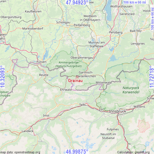
Grainau GPS coordinates[2]
47° 28' 34.104" North, 11° 1' 26.58" East
| Map corner | latitude | longitude |
|---|---|---|
| Upper-left | 47.94923°, | 10.32093° |
| Center: | 47.47614°, | 11.02405° |
| Lower-right: | 46.99875°, | 11.72718° |
| Map W x H: | 105.7×105.7 km | = 65.7×65.7mi |
| max Lat: | 55.01917° ⇑100% North |
| Grainau: | 47.47614° |
| min Lat: | ⇓0% South 47.40724° |
| min Long | Grainau | max Long |
| 5.92978° | 11.02405° | 14.98853° |
| W 67.3%⇐ | ⇒32.7% E |
Elevation
Elevation of Grainau is 749 m = 2457 ft, and this is 499.9 m = 1640 ft above average elevation for this country.
| Max E: |
1256 m = 4121 ft | 1.3% |
| Grainau | 749 m 2457 ft | |
| Avg. | 249.1 m = 817 ft | |
Min E: |
-5 m = -16 ft | 98.7% |
See also: Germany elevation on elevation.city.
Geographical zone
Grainau is located in North temperate zone (between Tropic of Cancer and the Arctic Circle). Distance of this North polar circle is 2122.3 km =1318.7 mi to North.| Distance of | km | miles | from Grainau |
|---|---|---|---|
| North Pole | 4728.2 | 2938 | to North |
| Arctic Circle | 2122.3 | 1318.7 | to North |
| Tropic Cancer | 2672.9 | 1660.9 | to South |
| Equator | 5278.9 | 3280.2 | to South |


Nearby cities:
15 places around Grainau: (largest is in red/bold)
• Bad Kohlgrub
21.3 km =13.2 mi,  5°
5°
• Eschenlohe
18.2 km =11.3 mi,  40°
40°
• Ettal
11.6 km =7.2 mi,  29°
29°
• Farchant
8.9 km =5.5 mi,  47°
47°
• Garmisch-Partenkirchen
5.7 km =3.5 mi,  71°
71°
• Halblech
23.1 km =14.4 mi,  318°
318°
• Hohenschwangau
23.1 km =14.4 mi,  292°
292°
• Krün
19.4 km =12.1 mi,  80°
80°
• Mittenwald
18.3 km =11.4 mi,  101°
101°
• Oberammergau
13.9 km =8.6 mi, 13°
• Oberau
12.7 km =7.9 mi, 42°
• Saulgrub
21.2 km =13.2 mi,  0°
0°
• Schwaigen
18.3 km =11.4 mi, 31°
• Unterammergau
15.6 km =9.7 mi, 0°
• Wallgau
20 km =12.4 mi, 76°
Sources, notices
• [Note1] Compared only with cities in Germany existing in our database
• [Src1] Map data: © OpenStreetMap contributors (CC-BY-SA)
• [Src2] Other city data from geonames.org with taken over terms of usage.
• [Src3] Geographical zone / Annual Mean Temperature by Robert A. Rohde @ Wikipedia
