Bischofsmais geodata
Bischofsmais (Bavaria) is a seat of a fourth-order administrative division; located in Germany in Europe/Berlin (GMT+2) time zone. With population of 3,240 people, there are 3796 cities with bigger population in this country. Compared to other cities in Germany, 83.8% of cities are located further ↑North; 92.8% of cities are located further ←West and 97.4% of cities have lower elevation than Bischofsmais. Note1
Administrative division(s):
- Level 1: Bavaria
- Level 2: Lower Bavaria
- Level 3: Landkreis Regen
- Level 4: Bischofsmais


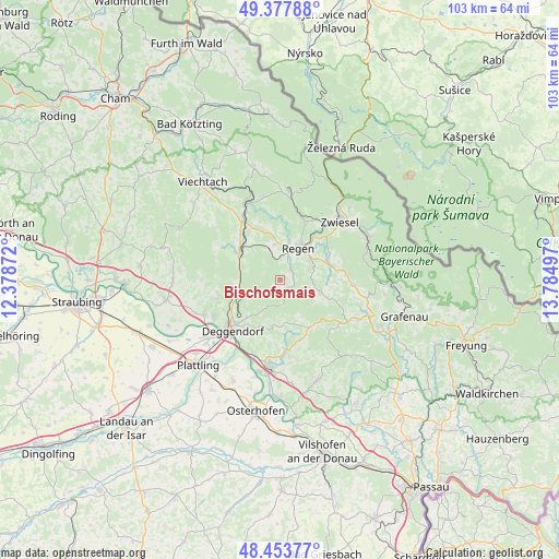
Bischofsmais GPS coordinates[2]
48° 55' 4.656" North, 13° 4' 54.624" East
| Map corner | latitude | longitude |
|---|---|---|
| Upper-left | 49.37788°, | 12.37872° |
| Center: | 48.91796°, | 13.08184° |
| Lower-right: | 48.45377°, | 13.78497° |
| Map W x H: | 102.8×102.7 km | = 63.9×63.8mi |
| max Lat: | 55.01917° ⇑83.8% North |
| Bischofsmais: | 48.91796° |
| min Lat: | ⇓16.2% South 47.40724° |
| min Long | Bischofsmais | max Long |
| 5.92978° | 13.08184° | 14.98853° |
| W 92.8%⇐ | ⇒7.2% E |
Elevation
Elevation of Bischofsmais is 680 m = 2231 ft, and this is 430.9 m = 1414 ft above average elevation for this country.
| Max E: |
1256 m = 4121 ft | 2.6% |
| Bischofsmais | 680 m 2231 ft | |
| Avg. | 249.1 m = 817 ft | |
Min E: |
-5 m = -16 ft | 97.4% |
See also: Germany elevation on elevation.city.
Geographical zone
Bischofsmais is located in North temperate zone (between Tropic of Cancer and the Arctic Circle). Distance of this North polar circle is 1962 km =1219.1 mi to North.| Distance of | km | miles | from Bischofsmais |
|---|---|---|---|
| North Pole | 4567.9 | 2838.4 | to North |
| Arctic Circle | 1962 | 1219.1 | to North |
| Tropic Cancer | 2833.2 | 1760.5 | to South |
| Equator | 5439.2 | 3379.8 | to South |


Nearby cities:
15 places around Bischofsmais: (largest is in red/bold)
• Achslach
12.3 km =7.6 mi,  299°
299°
• Auerbach
12.8 km =8 mi,  174°
174°
• Deggendorf
12.3 km =7.6 mi,  225°
225°
• Gotteszell
10 km =6.2 mi, 302°
• Grafling
8.2 km =5.1 mi,  251°
251°
• Hunding
10.9 km =6.8 mi,  140°
140°
• Kirchberg
7.6 km =4.7 mi,  105°
105°
• Lalling
9.1 km =5.7 mi,  152°
152°
• Langdorf
11.8 km =7.3 mi,  23°
23°
• Patersdorf
13.1 km =8.1 mi,  326°
326°
• Regen
6.9 km =4.3 mi,  29°
29°
• Rinchnach
9.4 km =5.8 mi,  68°
68°
• Ruhmannsfelden
10.2 km =6.3 mi,  315°
315°
• Schaufling
7.6 km =4.7 mi,  188°
188°
• Zachenberg
8.1 km =5 mi,  312°
312°
Sources, notices
• [Note1] Compared only with cities in Germany existing in our database
• [Src1] Map data: © OpenStreetMap contributors (CC-BY-SA)
• [Src2] Other city data from geonames.org with taken over terms of usage.
• [Src3] Geographical zone / Annual Mean Temperature by Robert A. Rohde @ Wikipedia
