Thum geodata
Thum (Saxony) is a populated place; located in Germany in Europe/Berlin (GMT+2) time zone. With population of 5,892 people, there are 2495 cities with bigger population in this country. Compared to other cities in Germany, 51.3% of cities are located further ↓South; 91.9% of cities are located further ←West and 89.6% of cities have lower elevation than Thum. Note1


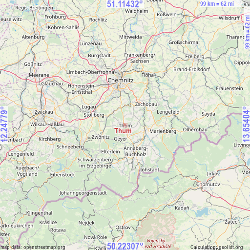
Thum GPS coordinates[2]
50° 40' 14.916" North, 12° 57' 3.276" East
| Map corner | latitude | longitude |
|---|---|---|
| Upper-left | 51.11432°, | 12.24779° |
| Center: | 50.67081°, | 12.95091° |
| Lower-right: | 50.22307°, | 13.65404° |
| Map W x H: | 99.1×99.1 km | = 61.6×61.6mi |
| max Lat: | 55.01917° ⇑48.7% North |
| Thum: | 50.67081° |
| min Lat: | ⇓51.3% South 47.40724° |
| min Long | Thum | max Long |
| 5.92978° | 12.95091° | 14.98853° |
| W 91.9%⇐ | ⇒8.1% E |
Elevation
Elevation of Thum is 509 m = 1670 ft, and this is 259.9 m = 853 ft above average elevation for this country.
| Max E: |
1256 m = 4121 ft | 10.4% |
| Thum | 509 m 1670 ft | |
| Avg. | 249.1 m = 817 ft | |
Min E: |
-5 m = -16 ft | 89.6% |
See also: Germany elevation on elevation.city.
Geographical zone
Thum is located in North temperate zone (between Tropic of Cancer and the Arctic Circle). Distance of this North polar circle is 1767.1 km =1098 mi to North.| Distance of | km | miles | from Thum |
|---|---|---|---|
| North Pole | 4373 | 2717.3 | to North |
| Arctic Circle | 1767.1 | 1098 | to North |
| Tropic Cancer | 3028.1 | 1881.6 | to South |
| Equator | 5634.1 | 3500.9 | to South |


Nearby cities:
15 places around Thum: (largest is in red/bold)
• Auerbach
2.8 km =1.7 mi,  299°
299°
• Burkhardtsdorf
7.4 km =4.6 mi,  340°
340°
• Dorfchemnitz
8.1 km =5 mi,  264°
264°
• Drebach
4.6 km =2.9 mi,  83°
83°
• Ehrenfriedersdorf
2.7 km =1.7 mi,  150°
150°
• Gelenau
4.7 km =2.9 mi,  13°
13°
• Geyer
5.4 km =3.4 mi,  203°
203°
• Gornsdorf
5.8 km =3.6 mi, 304°
• Hormersdorf
4.9 km =3 mi,  274°
274°
• Scharfenstein
8.3 km =5.2 mi,  63°
63°
• Tannenberg
7.1 km =4.4 mi,  187°
187°
• Thalheim
7.9 km =4.9 mi, 295°
• Venusberg
5.7 km =3.5 mi, 56°
• Wiesa
8 km =5 mi, 146°
• Wolkenstein
8.7 km =5.4 mi,  101°
101°
Sources, notices
• [Note1] Compared only with cities in Germany existing in our database
• [Src1] Map data: © OpenStreetMap contributors (CC-BY-SA)
• [Src2] Other city data from geonames.org with taken over terms of usage.
• [Src3] Geographical zone / Annual Mean Temperature by Robert A. Rohde @ Wikipedia
