Bruchsal geodata
Bruchsal (Baden-Württemberg) is a populated place; located in Germany in Europe/Berlin (GMT+2) time zone. With population of 42,785 people, there are 287 cities with bigger population in this country. Compared to other cities in Germany, 81.4% of cities are located further ↑North; 70.2% of cities are located further →East and 65.4% of cities have higher elevation than Bruchsal. Note1
Administrative division(s):
- Level 1: Baden-Württemberg
- Level 2: Karlsruhe Region
- Level 3: Landkreis Karlsruhe
- Level 4: Bruchsal


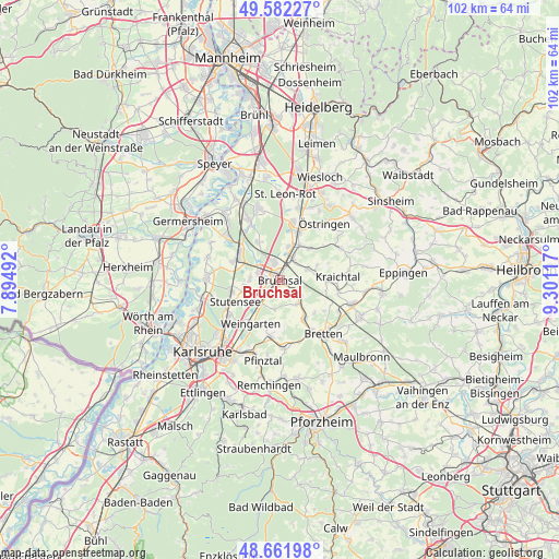
Bruchsal GPS coordinates[2]
49° 7' 27.336" North, 8° 35' 52.944" East
| Map corner | latitude | longitude |
|---|---|---|
| Upper-left | 49.58227°, | 7.89492° |
| Center: | 49.12426°, | 8.59804° |
| Lower-right: | 48.66198°, | 9.30117° |
| Map W x H: | 102.3×102.3 km | = 63.6×63.6mi |
| max Lat: | 55.01917° ⇑81.4% North |
| Bruchsal: | 49.12426° |
| min Lat: | ⇓18.6% South 47.40724° |
| min Long | Bruchsal | max Long |
| 5.92978° | 8.59804° | 14.98853° |
| W 29.8%⇐ | ⇒70.2% E |
Elevation
Elevation of Bruchsal is 118 m = 387 ft, and this is 131.1 m = 430 ft below average elevation for this country.
| Max E: |
1256 m = 4121 ft | 65.4% |
| Avg. | 249.1 m = 817 ft | |
| Bruchsal | 118 m = 387 ft | |
Min E: |
-5 m = -16 ft | 34.6% |
See also: Bruchsal elevation on elevation.city.
Geographical zone
Bruchsal is located in North temperate zone (between Tropic of Cancer and the Arctic Circle). Distance of this North polar circle is 1939.1 km =1204.9 mi to North.| Distance of | km | miles | from Bruchsal |
|---|---|---|---|
| North Pole | 4545 | 2824.1 | to North |
| Arctic Circle | 1939.1 | 1204.9 | to North |
| Tropic Cancer | 2856.2 | 1774.8 | to South |
| Equator | 5462.1 | 3394 | to South |


Nearby cities:
15 places around Bruchsal: (largest is in red/bold)
• Bretten
12.6 km =7.8 mi,  140°
140°
• Dürrenbüchig
12 km =7.5 mi,  162°
162°
• Forst
4 km =2.5 mi,  341°
341°
• Gondelsheim
8.5 km =5.3 mi,  148°
148°
• Graben-Neudorf
9 km =5.6 mi,  301°
301°
• Hambrücken
8.4 km =5.2 mi,  330°
330°
• Jöhlingen
10.4 km =6.5 mi,  189°
189°
• Karlsdorf-Neuthard
5.1 km =3.2 mi,  283°
283°
• Kraichtal
10.1 km =6.3 mi,  76°
76°
• Kronau
11.2 km =7 mi,  12°
12°
• Linkenheim-Hochstetten
13.5 km =8.4 mi,  273°
273°
• Ubstadt-Weiher
4.9 km =3 mi,  29°
29°
• Weingarten
9.3 km =5.8 mi,  213°
213°
• Wössingen
12.5 km =7.8 mi,  176°
176°
• Östringen
13.4 km =8.3 mi,  38°
38°
Sources, notices
• [Note1] Compared only with cities in Germany existing in our database
• [Src1] Map data: © OpenStreetMap contributors (CC-BY-SA)
• [Src2] Other city data from geonames.org with taken over terms of usage.
• [Src3] Geographical zone / Annual Mean Temperature by Robert A. Rohde @ Wikipedia
