Mutlangen geodata
Mutlangen (Baden-Württemberg) is a seat of a fourth-order administrative division; located in Germany in Europe/Berlin (GMT+1) time zone. With population of 6,431 people, there are 2322 cities with bigger population in this country. Compared to other cities in Germany, 85% of cities are located further ↑North; 52.8% of cities are located further →East and 82.8% of cities have lower elevation than Mutlangen. Note1
Administrative division(s):
- Level 1: Baden-Württemberg
- Level 2: Regierungsbezirk Stuttgart
- Level 3: Ostalbkreis
- Level 4: Mutlangen


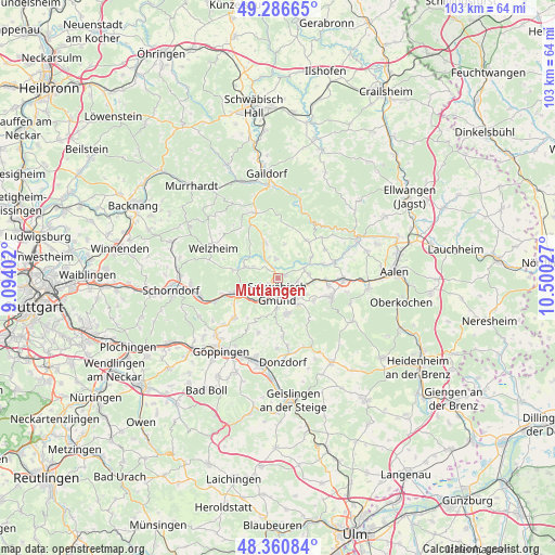
Mutlangen GPS coordinates[2]
48° 49' 33.168" North, 9° 47' 49.704" East
| Map corner | latitude | longitude |
|---|---|---|
| Upper-left | 49.28665°, | 9.09402° |
| Center: | 48.82588°, | 9.79714° |
| Lower-right: | 48.36084°, | 10.50027° |
| Map W x H: | 102.9×102.9 km | = 63.9×63.9mi |
| max Lat: | 55.01917° ⇑85% North |
| Mutlangen: | 48.82588° |
| min Lat: | ⇓15% South 47.40724° |
| min Long | Mutlangen | max Long |
| 5.92978° | 9.79714° | 14.98853° |
| W 47.2%⇐ | ⇒52.8% E |
Elevation
Elevation of Mutlangen is 452 m = 1483 ft, and this is 202.9 m = 666 ft above average elevation for this country.
| Max E: |
1256 m = 4121 ft | 17.2% |
| Mutlangen | 452 m 1483 ft | |
| Avg. | 249.1 m = 817 ft | |
Min E: |
-5 m = -16 ft | 82.8% |
See also: Germany elevation on elevation.city.
Geographical zone
Mutlangen is located in North temperate zone (between Tropic of Cancer and the Arctic Circle). Distance of this North polar circle is 1972.2 km =1225.5 mi to North.| Distance of | km | miles | from Mutlangen |
|---|---|---|---|
| North Pole | 4578.1 | 2844.7 | to North |
| Arctic Circle | 1972.2 | 1225.5 | to North |
| Tropic Cancer | 2823 | 1754.1 | to South |
| Equator | 5428.9 | 3373.4 | to South |


Nearby cities:
15 places around Mutlangen: (largest is in red/bold)
• Alfdorf
6.1 km =3.8 mi,  289°
289°
• Böbingen an der Rems
9.1 km =5.7 mi,  94°
94°
• Durlangen
3.4 km =2.1 mi,  359°
359°
• Eschach
8.8 km =5.5 mi,  37°
37°
• Göggingen
7.5 km =4.7 mi,  58°
58°
• Iggingen
6 km =3.7 mi,  83°
83°
• Leinzell
6.4 km =4 mi,  66°
66°
• Lorch
8.3 km =5.2 mi,  248°
248°
• Ottenbach
10.6 km =6.6 mi,  199°
199°
• Ruppertshofen
6.5 km =4 mi,  11°
11°
• Schechingen
10.3 km =6.4 mi, 59°
• Schwäbisch Gmünd
2.9 km =1.8 mi,  178°
178°
• Spraitbach
6.6 km =4.1 mi,  337°
337°
• Täferrot
4 km =2.5 mi,  48°
48°
• Waldstetten
6.9 km =4.3 mi,  165°
165°
Sources, notices
• [Note1] Compared only with cities in Germany existing in our database
• [Src1] Map data: © OpenStreetMap contributors (CC-BY-SA)
• [Src2] Other city data from geonames.org with taken over terms of usage.
• [Src3] Geographical zone / Annual Mean Temperature by Robert A. Rohde @ Wikipedia
