Heubach geodata
Heubach (Baden-Württemberg) is a populated place; located in Germany in Europe/Berlin (GMT+2) time zone. With population of 10,167 people, there are 1610 cities with bigger population in this country. Compared to other cities in Germany, 85.4% of cities are located further ↑North; 51% of cities are located further →East and 82.8% of cities have lower elevation than Heubach. Note1
Administrative division(s):
- Level 1: Baden-Württemberg
- Level 2: Regierungsbezirk Stuttgart
- Level 3: Ostalbkreis
- Level 4: Heubach


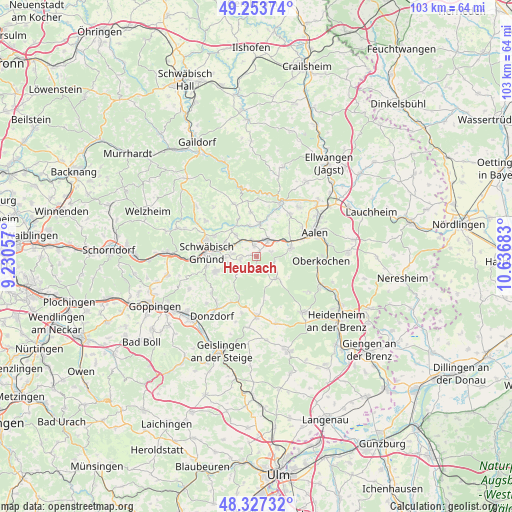
Heubach GPS coordinates[2]
48° 47' 33.612" North, 9° 56' 1.32" East
| Map corner | latitude | longitude |
|---|---|---|
| Upper-left | 49.25374°, | 9.23057° |
| Center: | 48.79267°, | 9.9337° |
| Lower-right: | 48.32732°, | 10.63683° |
| Map W x H: | 103×103 km | = 64×64mi |
| max Lat: | 55.01917° ⇑85.4% North |
| Heubach: | 48.79267° |
| min Lat: | ⇓14.6% South 47.40724° |
| min Long | Heubach | max Long |
| 5.92978° | 9.9337° | 14.98853° |
| W 49%⇐ | ⇒51% E |
Elevation
Elevation of Heubach is 452 m = 1483 ft, and this is 202.9 m = 666 ft above average elevation for this country.
| Max E: |
1256 m = 4121 ft | 17.2% |
| Heubach | 452 m 1483 ft | |
| Avg. | 249.1 m = 817 ft | |
Min E: |
-5 m = -16 ft | 82.8% |
See also: Germany elevation on elevation.city.
Geographical zone
Heubach is located in North temperate zone (between Tropic of Cancer and the Arctic Circle). Distance of this North polar circle is 1975.9 km =1227.8 mi to North.| Distance of | km | miles | from Heubach |
|---|---|---|---|
| North Pole | 4581.8 | 2847 | to North |
| Arctic Circle | 1975.9 | 1227.8 | to North |
| Tropic Cancer | 2819.3 | 1751.8 | to South |
| Equator | 5425.2 | 3371.1 | to South |


Nearby cities:
15 places around Heubach: (largest is in red/bold)
• Bartholomä
5.9 km =3.7 mi,  137°
137°
• Böbingen an der Rems
3.1 km =1.9 mi,  343°
343°
• Eschach
11.6 km =7.2 mi, 336°
• Essingen
7.1 km =4.4 mi,  75°
75°
• Göggingen
8.4 km =5.2 mi,  334°
334°
• Heuchlingen
6.7 km =4.2 mi,  6°
6°
• Iggingen
5.9 km =3.7 mi,  317°
317°
• Leinzell
7.5 km =4.7 mi, 326°
• Mutlangen
10.7 km =6.6 mi,  290°
290°
• Mögglingen
4 km =2.5 mi,  31°
31°
• Obergröningen
11.5 km =7.1 mi,  351°
351°
• Schechingen
9.1 km =5.7 mi, 352°
• Schwäbisch Gmünd
10 km =6.2 mi,  274°
274°
• Täferrot
9.4 km =5.8 mi,  312°
312°
• Waldstetten
8.7 km =5.4 mi,  250°
250°
Sources, notices
• [Note1] Compared only with cities in Germany existing in our database
• [Src1] Map data: © OpenStreetMap contributors (CC-BY-SA)
• [Src2] Other city data from geonames.org with taken over terms of usage.
• [Src3] Geographical zone / Annual Mean Temperature by Robert A. Rohde @ Wikipedia
