Mögglingen geodata
Mögglingen (Baden-Württemberg) is a seat of a fourth-order administrative division; located in Germany in Europe/Berlin (GMT+2) time zone. With population of 4,085 people, there are 3245 cities with bigger population in this country. Compared to other cities in Germany, 85.1% of cities are located further ↑North; 50.6% of cities are located further →East and 77% of cities have lower elevation than Mögglingen. Note1
Administrative division(s):
- Level 1: Baden-Württemberg
- Level 2: Regierungsbezirk Stuttgart
- Level 3: Ostalbkreis
- Level 4: Mögglingen


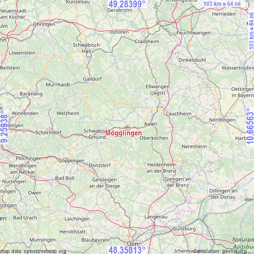
Mögglingen GPS coordinates[2]
48° 49' 23.52" North, 9° 57' 45" East
| Map corner | latitude | longitude |
|---|---|---|
| Upper-left | 49.28399°, | 9.25938° |
| Center: | 48.8232°, | 9.9625° |
| Lower-right: | 48.35813°, | 10.66563° |
| Map W x H: | 102.9×102.9 km | = 63.9×63.9mi |
| max Lat: | 55.01917° ⇑85.1% North |
| Mögglingen: | 48.8232° |
| min Lat: | ⇓14.9% South 47.40724° |
| min Long | Mögglingen | max Long |
| 5.92978° | 9.9625° | 14.98853° |
| W 49.4%⇐ | ⇒50.6% E |
Elevation
Elevation of Mögglingen is 412 m = 1352 ft, and this is 162.9 m = 534 ft above average elevation for this country.
| Max E: |
1256 m = 4121 ft | 23% |
| Mögglingen | 412 m 1352 ft | |
| Avg. | 249.1 m = 817 ft | |
Min E: |
-5 m = -16 ft | 77% |
See also: Germany elevation on elevation.city.
Geographical zone
Mögglingen is located in North temperate zone (between Tropic of Cancer and the Arctic Circle). Distance of this North polar circle is 1972.5 km =1225.7 mi to North.| Distance of | km | miles | from Mögglingen |
|---|---|---|---|
| North Pole | 4578.4 | 2844.9 | to North |
| Arctic Circle | 1972.5 | 1225.7 | to North |
| Tropic Cancer | 2822.7 | 1753.9 | to South |
| Equator | 5428.6 | 3373.2 | to South |


Nearby cities:
15 places around Mögglingen: (largest is in red/bold)
• Aalen
9.7 km =6 mi,  80°
80°
• Abtsgmünd
8.5 km =5.3 mi,  19°
19°
• Bartholomä
8 km =5 mi,  166°
166°
• Böbingen an der Rems
3 km =1.9 mi,  262°
262°
• Eschach
9.9 km =6.2 mi,  316°
316°
• Essingen
5 km =3.1 mi,  108°
108°
• Göggingen
7.1 km =4.4 mi,  306°
306°
• Heubach
4 km =2.5 mi,  211°
211°
• Heuchlingen
3.5 km =2.2 mi,  337°
337°
• Iggingen
6.2 km =3.9 mi,  278°
278°
• Leinzell
6.9 km =4.3 mi,  295°
295°
• Obergröningen
8.8 km =5.5 mi,  333°
333°
• Oberkochen
11.3 km =7 mi, 112°
• Schechingen
6.5 km =4 mi, 329°
• Täferrot
9.6 km =6 mi,  287°
287°
Sources, notices
• [Note1] Compared only with cities in Germany existing in our database
• [Src1] Map data: © OpenStreetMap contributors (CC-BY-SA)
• [Src2] Other city data from geonames.org with taken over terms of usage.
• [Src3] Geographical zone / Annual Mean Temperature by Robert A. Rohde @ Wikipedia
