Tuntenhausen geodata
Tuntenhausen (Bavaria) is a seat of a fourth-order administrative division; located in Germany in Europe/Berlin (GMT+2) time zone. With population of 6,642 people, there are 2267 cities with bigger population in this country. Compared to other cities in Germany, 96.2% of cities are located further ↑North; 82% of cities are located further ←West and 88.9% of cities have lower elevation than Tuntenhausen. Note1
Administrative division(s):
- Level 1: Bavaria
- Level 2: Upper Bavaria
- Level 3: Landkreis Rosenheim
- Level 4: Tuntenhausen


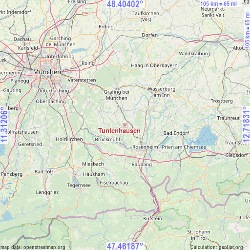
Tuntenhausen GPS coordinates[2]
47° 56' 6.324" North, 12° 0' 54.648" East
| Map corner | latitude | longitude |
|---|---|---|
| Upper-left | 48.40402°, | 11.31206° |
| Center: | 47.93509°, | 12.01518° |
| Lower-right: | 47.46187°, | 12.71831° |
| Map W x H: | 104.8×104.8 km | = 65.1×65.1mi |
| max Lat: | 55.01917° ⇑96.2% North |
| Tuntenhausen: | 47.93509° |
| min Lat: | ⇓3.8% South 47.40724° |
| min Long | Tuntenhausen | max Long |
| 5.92978° | 12.01518° | 14.98853° |
| W 82%⇐ | ⇒18% E |
Elevation
Elevation of Tuntenhausen is 503 m = 1650 ft, and this is 253.9 m = 833 ft above average elevation for this country.
| Max E: |
1256 m = 4121 ft | 11.1% |
| Tuntenhausen | 503 m 1650 ft | |
| Avg. | 249.1 m = 817 ft | |
Min E: |
-5 m = -16 ft | 88.9% |
See also: Germany elevation on elevation.city.
Geographical zone
Tuntenhausen is located in North temperate zone (between Tropic of Cancer and the Arctic Circle). Distance of this North polar circle is 2071.3 km =1287 mi to North.| Distance of | km | miles | from Tuntenhausen |
|---|---|---|---|
| North Pole | 4677.2 | 2906.3 | to North |
| Arctic Circle | 2071.3 | 1287 | to North |
| Tropic Cancer | 2724 | 1692.6 | to South |
| Equator | 5329.9 | 3311.8 | to South |


Nearby cities:
15 places around Tuntenhausen: (largest is in red/bold)
• Aßling
6.5 km =4 mi,  354°
354°
• Bad Aibling
7.9 km =4.9 mi,  182°
182°
• Bruckmühl
10 km =6.2 mi,  231°
231°
• Emmering
7.6 km =4.7 mi,  23°
23°
• Eschenlohe
9.2 km =5.7 mi,  6°
6°
• Fraueneuharting
11.8 km =7.3 mi, 11°
• Glonn
12.5 km =7.8 mi,  297°
297°
• Großkarolinenfeld
6.9 km =4.3 mi,  134°
134°
• Hohenthann
6.4 km =4 mi,  317°
317°
• Kolbermoor
10.3 km =6.4 mi,  157°
157°
• Rosenheim
11.9 km =7.4 mi,  137°
137°
• Rott
5.7 km =3.5 mi,  107°
107°
• Schechen
8.1 km =5 mi,  94°
94°
• Vagen
11.9 km =7.4 mi,  235°
235°
• Vogtareuth
12.4 km =7.7 mi,  83°
83°
Sources, notices
• [Note1] Compared only with cities in Germany existing in our database
• [Src1] Map data: © OpenStreetMap contributors (CC-BY-SA)
• [Src2] Other city data from geonames.org with taken over terms of usage.
• [Src3] Geographical zone / Annual Mean Temperature by Robert A. Rohde @ Wikipedia
