Westhausen geodata
Westhausen (Thuringia) is a seat of a fourth-order administrative division; located in Germany in Europe/Berlin (GMT+2) time zone. With population of 580 people, there are 8920 cities with bigger population in this country. Compared to other cities in Germany, 56.5% of cities are located further ↑North; 61.9% of cities are located further ←West and 64.2% of cities have lower elevation than Westhausen. Note1
Administrative division(s):
- Level 1: Thuringia
- Level 3: Landkreis Hildburghausen
- Level 4: Westhausen


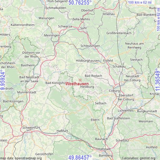
Westhausen GPS coordinates[2]
50° 18' 56.448" North, 10° 39' 44.496" East
| Map corner | latitude | longitude |
|---|---|---|
| Upper-left | 50.76255°, | 9.95924° |
| Center: | 50.31568°, | 10.66236° |
| Lower-right: | 49.86457°, | 11.36549° |
| Map W x H: | 99.8×99.8 km | = 62×62mi |
| max Lat: | 55.01917° ⇑56.5% North |
| Westhausen: | 50.31568° |
| min Lat: | ⇓43.5% South 47.40724° |
| min Long | Westhausen | max Long |
| 5.92978° | 10.66236° | 14.98853° |
| W 61.9%⇐ | ⇒38.1% E |
Elevation
Elevation of Westhausen is 316 m = 1037 ft, and this is 66.9 m = 219 ft above average elevation for this country.
| Max E: |
1256 m = 4121 ft | 35.8% |
| Westhausen | 316 m 1037 ft | |
| Avg. | 249.1 m = 817 ft | |
Min E: |
-5 m = -16 ft | 64.2% |
See also: Germany elevation on elevation.city.
Geographical zone
Westhausen is located in North temperate zone (between Tropic of Cancer and the Arctic Circle). Distance of this North polar circle is 1806.6 km =1122.6 mi to North.| Distance of | km | miles | from Westhausen |
|---|---|---|---|
| North Pole | 4412.5 | 2741.8 | to North |
| Arctic Circle | 1806.6 | 1122.6 | to North |
| Tropic Cancer | 2988.7 | 1857.1 | to South |
| Equator | 5594.6 | 3476.3 | to South |


Nearby cities:
15 places around Westhausen: (largest is in red/bold)
• Bad Königshofen im Grabfeld
13.8 km =8.6 mi,  263°
263°
• Dingsleben
13.8 km =8.6 mi,  341°
341°
• Ermershausen
12.2 km =7.6 mi,  192°
192°
• Gleichamberg
7.6 km =4.7 mi,  323°
323°
• Gompertshausen
3.3 km =2.1 mi,  234°
234°
• Hellingen
7.5 km =4.7 mi,  168°
168°
• Herbstadt
11.7 km =7.3 mi,  279°
279°
• Hildburghausen
13.2 km =8.2 mi,  21°
21°
• Maroldsweisach
13.3 km =8.3 mi,  180°
180°
• Milz
11.2 km =7 mi,  307°
307°
• Reurieth
15 km =9.3 mi,  356°
356°
• Römhild
12.5 km =7.8 mi, 315°
• Trappstadt
6.6 km =4.1 mi,  273°
273°
• Ummerstadt
12.4 km =7.7 mi,  120°
120°
• Veilsdorf
14.7 km =9.1 mi,  45°
45°
Sources, notices
• [Note1] Compared only with cities in Germany existing in our database
• [Src1] Map data: © OpenStreetMap contributors (CC-BY-SA)
• [Src2] Other city data from geonames.org with taken over terms of usage.
• [Src3] Geographical zone / Annual Mean Temperature by Robert A. Rohde @ Wikipedia
