Jesberg geodata
Jesberg (Hesse) is a seat of a fourth-order administrative division; located in Germany in Europe/Berlin (GMT+2) time zone. With population of 2,655 people, there are 4274 cities with bigger population in this country. Compared to other cities in Germany, 58.1% of cities are located further ↓South; 63.3% of cities are located further →East and 51.1% of cities have lower elevation than Jesberg. Note1
Administrative division(s):
- Level 1: Hesse
- Level 2: Regierungsbezirk Kassel
- Level 3: Schwalm-Eder-Kreis
- Level 4: Jesberg


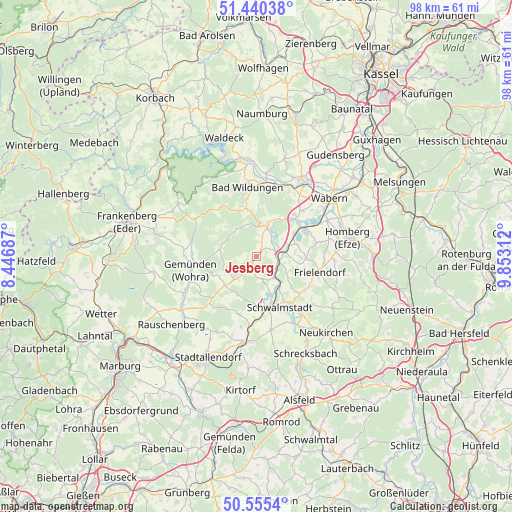
Jesberg GPS coordinates[2]
51° 0' 0" North, 9° 9' 0" East
| Map corner | latitude | longitude |
|---|---|---|
| Upper-left | 51.44038°, | 8.44687° |
| Center: | 51°, | 9.15° |
| Lower-right: | 50.5554°, | 9.85312° |
| Map W x H: | 98.4×98.4 km | = 61.1×61.1mi |
| max Lat: | 55.01917° ⇑41.9% North |
| Jesberg: | 51° |
| min Lat: | ⇓58.1% South 47.40724° |
| min Long | Jesberg | max Long |
| 5.92978° | 9.15° | 14.98853° |
| W 36.7%⇐ | ⇒63.3% E |
Elevation
Elevation of Jesberg is 234 m = 768 ft, and this is 15.1 m = 50 ft below average elevation for this country.
| Max E: |
1256 m = 4121 ft | 48.9% |
| Avg. | 249.1 m = 817 ft | |
| Jesberg | 234 m = 768 ft | |
Min E: |
-5 m = -16 ft | 51.1% |
See also: Germany elevation on elevation.city.
Geographical zone
Jesberg is located in North temperate zone (between Tropic of Cancer and the Arctic Circle). Distance of this North polar circle is 1730.5 km =1075.3 mi to North.| Distance of | km | miles | from Jesberg |
|---|---|---|---|
| North Pole | 4336.4 | 2694.5 | to North |
| Arctic Circle | 1730.5 | 1075.3 | to North |
| Tropic Cancer | 3064.7 | 1904.3 | to South |
| Equator | 5670.7 | 3523.6 | to South |


Nearby cities:
15 places around Jesberg: (largest is in red/bold)
• Bad Wildungen
13.4 km =8.3 mi,  352°
352°
• Borken
10.6 km =6.6 mi,  61°
61°
• Frielendorf
12.5 km =7.8 mi,  105°
105°
• Fritzlar
17.1 km =10.6 mi,  30°
30°
• Gemünden an der Wohra
13 km =8.1 mi,  257°
257°
• Gilserberg
8.1 km =5 mi,  226°
226°
• Haina
12.7 km =7.9 mi,  284°
284°
• Neuental
4.7 km =2.9 mi,  90°
90°
• Neustadt (Hessen)
16.8 km =10.4 mi,  187°
187°
• Reinhardshausen
13.5 km =8.4 mi,  337°
337°
• Riebelsdorf
17.5 km =10.9 mi,  140°
140°
• Schwalmstadt
8.8 km =5.5 mi,  147°
147°
• Seigertshausen
17.6 km =10.9 mi,  124°
124°
• Wabern
17.9 km =11.1 mi,  51°
51°
• Willingshausen
17 km =10.6 mi,  168°
168°
Sources, notices
• [Note1] Compared only with cities in Germany existing in our database
• [Src1] Map data: © OpenStreetMap contributors (CC-BY-SA)
• [Src2] Other city data from geonames.org with taken over terms of usage.
• [Src3] Geographical zone / Annual Mean Temperature by Robert A. Rohde @ Wikipedia
