Emskirchen geodata
Emskirchen (Bavaria) is a populated place; located in Germany in Europe/Berlin (GMT+2) time zone. With population of 6,197 people, there are 2402 cities with bigger population in this country. Compared to other cities in Germany, 74.7% of cities are located further ↑North; 62.6% of cities are located further ←West and 69.2% of cities have lower elevation than Emskirchen. Note1
Administrative division(s):
- Level 1: Bavaria
- Level 2: Regierungsbezirk Mittelfranken
- Level 3: Landkreis Neustadt an der Aisch-Bad Windsheim
- Level 4: Emskirchen, Markt


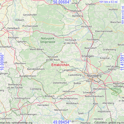
Emskirchen GPS coordinates[2]
49° 33' 10.152" North, 10° 42' 46.008" East
| Map corner | latitude | longitude |
|---|---|---|
| Upper-left | 50.00684°, | 10.00966° |
| Center: | 49.55282°, | 10.71278° |
| Lower-right: | 49.09454°, | 11.41591° |
| Map W x H: | 101.4×101.4 km | = 63×63mi |
| max Lat: | 55.01917° ⇑74.7% North |
| Emskirchen: | 49.55282° |
| min Lat: | ⇓25.3% South 47.40724° |
| min Long | Emskirchen | max Long |
| 5.92978° | 10.71278° | 14.98853° |
| W 62.6%⇐ | ⇒37.4% E |
Elevation
Elevation of Emskirchen is 352 m = 1155 ft, and this is 102.9 m = 338 ft above average elevation for this country.
| Max E: |
1256 m = 4121 ft | 30.8% |
| Emskirchen | 352 m 1155 ft | |
| Avg. | 249.1 m = 817 ft | |
Min E: |
-5 m = -16 ft | 69.2% |
See also: Germany elevation on elevation.city.
Geographical zone
Emskirchen is located in North temperate zone (between Tropic of Cancer and the Arctic Circle). Distance of this North polar circle is 1891.4 km =1175.3 mi to North.| Distance of | km | miles | from Emskirchen |
|---|---|---|---|
| North Pole | 4497.3 | 2794.5 | to North |
| Arctic Circle | 1891.4 | 1175.3 | to North |
| Tropic Cancer | 2903.8 | 1804.3 | to South |
| Equator | 5509.8 | 3423.6 | to South |


Nearby cities:
15 places around Emskirchen: (largest is in red/bold)
• Adelsdorf
9.4 km =5.8 mi,  192°
192°
• Diespeck
7.8 km =4.8 mi,  312°
312°
• Gerhardshofen
8.9 km =5.5 mi,  349°
349°
• Gutenstetten
9.1 km =5.7 mi,  321°
321°
• Hagenbüchach
4.5 km =2.8 mi,  119°
119°
• Langenzenn
8.6 km =5.3 mi,  138°
138°
• Markt Erlbach
7.9 km =4.9 mi,  213°
213°
• Neuhof an der Zenn
11.7 km =7.3 mi,  204°
204°
• Neustadt an der Aisch
7.9 km =4.9 mi,  292°
292°
• Oberreichenbach
5.7 km =3.5 mi,  44°
44°
• Puschendorf
9.2 km =5.7 mi,  110°
110°
• Tuchenbach
11 km =6.8 mi,  104°
104°
• Weisendorf
11.2 km =7 mi,  46°
46°
• Wilhelmsdorf
2.2 km =1.4 mi, 54°
• Wilhermsdorf
7.8 km =4.8 mi,  178°
178°
Sources, notices
• [Note1] Compared only with cities in Germany existing in our database
• [Src1] Map data: © OpenStreetMap contributors (CC-BY-SA)
• [Src2] Other city data from geonames.org with taken over terms of usage.
• [Src3] Geographical zone / Annual Mean Temperature by Robert A. Rohde @ Wikipedia
