Hagenbüchach geodata
Hagenbüchach (Bavaria) is a seat of a fourth-order administrative division; located in Germany in Europe/Berlin (GMT+2) time zone. With population of 1,251 people, there are 6438 cities with bigger population in this country. Compared to other cities in Germany, 75.2% of cities are located further ↑North; 63.5% of cities are located further ←West and 73.9% of cities have lower elevation than Hagenbüchach. Note1
Administrative division(s):
- Level 1: Bavaria
- Level 2: Regierungsbezirk Mittelfranken
- Level 3: Landkreis Neustadt an der Aisch-Bad Windsheim
- Level 4: Hagenbüchach


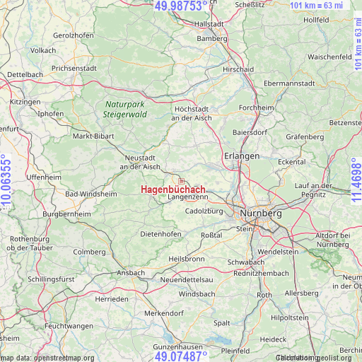
Hagenbüchach GPS coordinates[2]
49° 31' 59.988" North, 10° 46' 0.012" East
| Map corner | latitude | longitude |
|---|---|---|
| Upper-left | 49.98753°, | 10.06355° |
| Center: | 49.53333°, | 10.76667° |
| Lower-right: | 49.07487°, | 11.4698° |
| Map W x H: | 101.5×101.5 km | = 63.1×63.1mi |
| max Lat: | 55.01917° ⇑75.2% North |
| Hagenbüchach: | 49.53333° |
| min Lat: | ⇓24.8% South 47.40724° |
| min Long | Hagenbüchach | max Long |
| 5.92978° | 10.76667° | 14.98853° |
| W 63.5%⇐ | ⇒36.5% E |
Elevation
Elevation of Hagenbüchach is 389 m = 1276 ft, and this is 139.9 m = 459 ft above average elevation for this country.
| Max E: |
1256 m = 4121 ft | 26.1% |
| Hagenbüchach | 389 m 1276 ft | |
| Avg. | 249.1 m = 817 ft | |
Min E: |
-5 m = -16 ft | 73.9% |
See also: Germany elevation on elevation.city.
Geographical zone
Hagenbüchach is located in North temperate zone (between Tropic of Cancer and the Arctic Circle). Distance of this North polar circle is 1893.6 km =1176.6 mi to North.| Distance of | km | miles | from Hagenbüchach |
|---|---|---|---|
| North Pole | 4499.5 | 2795.9 | to North |
| Arctic Circle | 1893.6 | 1176.6 | to North |
| Tropic Cancer | 2901.7 | 1803 | to South |
| Equator | 5507.6 | 3422.3 | to South |


Nearby cities:
15 places around Hagenbüchach: (largest is in red/bold)
• Adelsdorf
9.2 km =5.7 mi,  219°
219°
• Cadolzburg
10.5 km =6.5 mi,  143°
143°
• Emskirchen
4.5 km =2.8 mi,  299°
299°
• Herzogenaurach
9.4 km =5.8 mi,  65°
65°
• Langenzenn
4.7 km =2.9 mi,  156°
156°
• Markt Erlbach
9.3 km =5.8 mi,  241°
241°
• Obermichelbach
10.3 km =6.4 mi,  91°
91°
• Oberreichenbach
6.2 km =3.9 mi,  1°
1°
• Puschendorf
4.8 km =3 mi,  102°
102°
• Seukendorf
9.6 km =6 mi,  121°
121°
• Tuchenbach
6.7 km =4.2 mi, 95°
• Veitsbronn
9.1 km =5.7 mi, 104°
• Weisendorf
10.8 km =6.7 mi,  23°
23°
• Wilhelmsdorf
4 km =2.5 mi,  328°
328°
• Wilhermsdorf
6.7 km =4.2 mi,  213°
213°
Sources, notices
• [Note1] Compared only with cities in Germany existing in our database
• [Src1] Map data: © OpenStreetMap contributors (CC-BY-SA)
• [Src2] Other city data from geonames.org with taken over terms of usage.
• [Src3] Geographical zone / Annual Mean Temperature by Robert A. Rohde @ Wikipedia
