Oberreichenbach geodata
Oberreichenbach (Bavaria) is a seat of a fourth-order administrative division; located in Germany in Europe/Berlin (GMT+2) time zone. With population of 1,204 people, there are 6550 cities with bigger population in this country. Compared to other cities in Germany, 74% of cities are located further ↑North; 63.6% of cities are located further ←West and 68.7% of cities have lower elevation than Oberreichenbach. Note1
Administrative division(s):
- Level 1: Bavaria
- Level 2: Regierungsbezirk Mittelfranken
- Level 3: Landkreis Erlangen-Höchstadt
- Level 4: Oberreichenbach


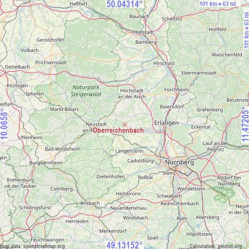
Oberreichenbach GPS coordinates[2]
49° 35' 22.056" North, 10° 46' 8.112" East
| Map corner | latitude | longitude |
|---|---|---|
| Upper-left | 50.04314°, | 10.0658° |
| Center: | 49.58946°, | 10.76892° |
| Lower-right: | 49.13152°, | 11.47205° |
| Map W x H: | 101.4×101.4 km | = 63×63mi |
| max Lat: | 55.01917° ⇑74% North |
| Oberreichenbach: | 49.58946° |
| min Lat: | ⇓26% South 47.40724° |
| min Long | Oberreichenbach | max Long |
| 5.92978° | 10.76892° | 14.98853° |
| W 63.6%⇐ | ⇒36.4% E |
Elevation
Elevation of Oberreichenbach is 348 m = 1142 ft, and this is 98.9 m = 324 ft above average elevation for this country.
| Max E: |
1256 m = 4121 ft | 31.3% |
| Oberreichenbach | 348 m 1142 ft | |
| Avg. | 249.1 m = 817 ft | |
Min E: |
-5 m = -16 ft | 68.7% |
See also: Germany elevation on elevation.city.
Geographical zone
Oberreichenbach is located in North temperate zone (between Tropic of Cancer and the Arctic Circle). Distance of this North polar circle is 1887.3 km =1172.7 mi to North.| Distance of | km | miles | from Oberreichenbach |
|---|---|---|---|
| North Pole | 4493.2 | 2791.9 | to North |
| Arctic Circle | 1887.3 | 1172.7 | to North |
| Tropic Cancer | 2907.9 | 1806.9 | to South |
| Equator | 5513.8 | 3426.1 | to South |


Nearby cities:
15 places around Oberreichenbach: (largest is in red/bold)
• Diespeck
9.8 km =6.1 mi,  276°
276°
• Emskirchen
5.7 km =3.5 mi,  224°
224°
• Gerhardshofen
7.3 km =4.5 mi,  309°
309°
• Großenseebach
9 km =5.6 mi,  57°
57°
• Gutenstetten
10.2 km =6.3 mi,  287°
287°
• Hagenbüchach
6.2 km =3.9 mi,  181°
181°
• Herzogenaurach
8.7 km =5.4 mi,  105°
105°
• Heßdorf
11 km =6.8 mi,  67°
67°
• Langenzenn
10.7 km =6.6 mi,  170°
170°
• Neustadt an der Aisch
11.4 km =7.1 mi,  264°
264°
• Puschendorf
8.6 km =5.3 mi,  148°
148°
• Tuchenbach
9.5 km =5.9 mi,  136°
136°
• Uehlfeld
9.7 km =6 mi,  338°
338°
• Weisendorf
5.5 km =3.4 mi,  47°
47°
• Wilhelmsdorf
3.6 km =2.2 mi, 219°
Sources, notices
• [Note1] Compared only with cities in Germany existing in our database
• [Src1] Map data: © OpenStreetMap contributors (CC-BY-SA)
• [Src2] Other city data from geonames.org with taken over terms of usage.
• [Src3] Geographical zone / Annual Mean Temperature by Robert A. Rohde @ Wikipedia
