Wilhelmsdorf geodata
Wilhelmsdorf (Bavaria) is a seat of a fourth-order administrative division; located in Germany in Europe/Berlin (GMT+2) time zone. With population of 1,269 people, there are 6390 cities with bigger population in this country. Compared to other cities in Germany, 74.5% of cities are located further ↑North; 63.1% of cities are located further ←West and 66.1% of cities have lower elevation than Wilhelmsdorf. Note1
Administrative division(s):
- Level 1: Bavaria
- Level 2: Regierungsbezirk Mittelfranken
- Level 3: Landkreis Neustadt an der Aisch-Bad Windsheim
- Level 4: Wilhelmsdorf


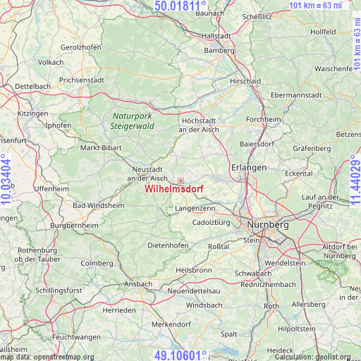
Wilhelmsdorf GPS coordinates[2]
49° 33' 51.084" North, 10° 44' 13.776" East
| Map corner | latitude | longitude |
|---|---|---|
| Upper-left | 50.01811°, | 10.03404° |
| Center: | 49.56419°, | 10.73716° |
| Lower-right: | 49.10601°, | 11.44029° |
| Map W x H: | 101.4×101.4 km | = 63×63mi |
| max Lat: | 55.01917° ⇑74.5% North |
| Wilhelmsdorf: | 49.56419° |
| min Lat: | ⇓25.5% South 47.40724° |
| min Long | Wilhelmsdorf | max Long |
| 5.92978° | 10.73716° | 14.98853° |
| W 63.1%⇐ | ⇒36.9% E |
Elevation
Elevation of Wilhelmsdorf is 329 m = 1079 ft, and this is 79.9 m = 262 ft above average elevation for this country.
| Max E: |
1256 m = 4121 ft | 33.9% |
| Wilhelmsdorf | 329 m 1079 ft | |
| Avg. | 249.1 m = 817 ft | |
Min E: |
-5 m = -16 ft | 66.1% |
See also: Germany elevation on elevation.city.
Geographical zone
Wilhelmsdorf is located in North temperate zone (between Tropic of Cancer and the Arctic Circle). Distance of this North polar circle is 1890.2 km =1174.5 mi to North.| Distance of | km | miles | from Wilhelmsdorf |
|---|---|---|---|
| North Pole | 4496 | 2793.7 | to North |
| Arctic Circle | 1890.2 | 1174.5 | to North |
| Tropic Cancer | 2905.1 | 1805.1 | to South |
| Equator | 5511 | 3424.4 | to South |


Nearby cities:
15 places around Wilhelmsdorf: (largest is in red/bold)
• Adelsdorf
11.1 km =6.9 mi,  199°
199°
• Diespeck
8.5 km =5.3 mi,  298°
298°
• Emskirchen
2.2 km =1.4 mi,  234°
234°
• Gerhardshofen
8.2 km =5.1 mi,  336°
336°
• Gutenstetten
9.5 km =5.9 mi,  307°
307°
• Hagenbüchach
4 km =2.5 mi,  148°
148°
• Herzogenaurach
10.7 km =6.6 mi,  87°
87°
• Langenzenn
8.7 km =5.4 mi, 152°
• Markt Erlbach
9.9 km =6.2 mi,  217°
217°
• Neustadt an der Aisch
9.2 km =5.7 mi,  280°
280°
• Oberreichenbach
3.6 km =2.2 mi,  39°
39°
• Puschendorf
8.2 km =5.1 mi,  123°
123°
• Tuchenbach
9.7 km =6 mi,  114°
114°
• Weisendorf
9.1 km =5.7 mi, 44°
• Wilhermsdorf
9.2 km =5.7 mi,  189°
189°
Sources, notices
• [Note1] Compared only with cities in Germany existing in our database
• [Src1] Map data: © OpenStreetMap contributors (CC-BY-SA)
• [Src2] Other city data from geonames.org with taken over terms of usage.
• [Src3] Geographical zone / Annual Mean Temperature by Robert A. Rohde @ Wikipedia
