Schwaara geodata
Schwaara (Thuringia) is a seat of a fourth-order administrative division; located in Germany in Europe/Berlin (GMT+2) time zone. With population of 166 people, there are 10611 cities with bigger population in this country. Compared to other cities in Germany, 56.2% of cities are located further ↓South; 83.8% of cities are located further ←West and 56.2% of cities have lower elevation than Schwaara. Note1


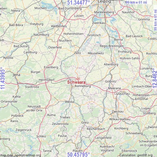
Schwaara GPS coordinates[2]
50° 54' 12.492" North, 12° 8' 35.052" East
| Map corner | latitude | longitude |
|---|---|---|
| Upper-left | 51.34477°, | 11.43995° |
| Center: | 50.90347°, | 12.14307° |
| Lower-right: | 50.45795°, | 12.8462° |
| Map W x H: | 98.6×98.6 km | = 61.3×61.3mi |
| max Lat: | 55.01917° ⇑43.8% North |
| Schwaara: | 50.90347° |
| min Lat: | ⇓56.2% South 47.40724° |
| min Long | Schwaara | max Long |
| 5.92978° | 12.14307° | 14.98853° |
| W 83.8%⇐ | ⇒16.2% E |
Elevation
Elevation of Schwaara is 267 m = 876 ft, and this is 17.9 m = 59 ft above average elevation for this country.
| Max E: |
1256 m = 4121 ft | 43.8% |
| Schwaara | 267 m 876 ft | |
| Avg. | 249.1 m = 817 ft | |
Min E: |
-5 m = -16 ft | 56.2% |
See also: Germany elevation on elevation.city.
Geographical zone
Schwaara is located in North temperate zone (between Tropic of Cancer and the Arctic Circle). Distance of this North polar circle is 1741.2 km =1081.9 mi to North.| Distance of | km | miles | from Schwaara |
|---|---|---|---|
| North Pole | 4347.1 | 2701.2 | to North |
| Arctic Circle | 1741.2 | 1081.9 | to North |
| Tropic Cancer | 3054 | 1897.7 | to South |
| Equator | 5659.9 | 3516.9 | to South |


Nearby cities:
15 places around Schwaara: (largest is in red/bold)
• Bad Köstritz
9.8 km =6.1 mi,  287°
287°
• Bethenhausen
4.9 km =3 mi,  54°
54°
• Brahmenau
2.5 km =1.6 mi,  26°
26°
• Gera
5 km =3.1 mi,  239°
239°
• Großenstein
4 km =2.5 mi,  95°
95°
• Hilbersdorf
9.7 km =6 mi,  177°
177°
• Hirschfeld
5.3 km =3.3 mi,  36°
36°
• Korbussen
2.5 km =1.6 mi,  125°
125°
• Löbichau
8.5 km =5.3 mi, 97°
• Paitzdorf
7.9 km =4.9 mi,  139°
139°
• Posterstein
9.6 km =6 mi,  115°
115°
• Pölzig
6.5 km =4 mi, 37°
• Ronneburg
5.4 km =3.4 mi,  145°
145°
• Schellbach
8.4 km =5.2 mi,  347°
347°
• Wittgendorf
9 km =5.6 mi,  23°
23°
Sources, notices
• [Note1] Compared only with cities in Germany existing in our database
• [Src1] Map data: © OpenStreetMap contributors (CC-BY-SA)
• [Src2] Other city data from geonames.org with taken over terms of usage.
• [Src3] Geographical zone / Annual Mean Temperature by Robert A. Rohde @ Wikipedia
