Ronneburg geodata
Ronneburg (Thuringia) is a populated place; located in Germany in Europe/Berlin (GMT+2) time zone. With population of 5,482 people, there are 2633 cities with bigger population in this country. Compared to other cities in Germany, 55.4% of cities are located further ↓South; 84.5% of cities are located further ←West and 59.1% of cities have lower elevation than Ronneburg. Note1


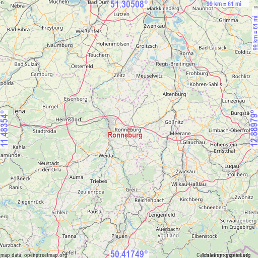
Ronneburg GPS coordinates[2]
50° 51' 48.24" North, 12° 11' 11.976" East
| Map corner | latitude | longitude |
|---|---|---|
| Upper-left | 51.30508°, | 11.48354° |
| Center: | 50.8634°, | 12.18666° |
| Lower-right: | 50.41749°, | 12.88979° |
| Map W x H: | 98.7×98.7 km | = 61.3×61.3mi |
| max Lat: | 55.01917° ⇑44.6% North |
| Ronneburg: | 50.8634° |
| min Lat: | ⇓55.4% South 47.40724° |
| min Long | Ronneburg | max Long |
| 5.92978° | 12.18666° | 14.98853° |
| W 84.5%⇐ | ⇒15.5% E |
Elevation
Elevation of Ronneburg is 284 m = 932 ft, and this is 34.9 m = 115 ft above average elevation for this country.
| Max E: |
1256 m = 4121 ft | 40.9% |
| Ronneburg | 284 m 932 ft | |
| Avg. | 249.1 m = 817 ft | |
Min E: |
-5 m = -16 ft | 59.1% |
See also: Germany elevation on elevation.city.
Geographical zone
Ronneburg is located in North temperate zone (between Tropic of Cancer and the Arctic Circle). Distance of this North polar circle is 1745.7 km =1084.7 mi to North.| Distance of | km | miles | from Ronneburg |
|---|---|---|---|
| North Pole | 4351.6 | 2704 | to North |
| Arctic Circle | 1745.7 | 1084.7 | to North |
| Tropic Cancer | 3049.6 | 1894.9 | to South |
| Equator | 5655.5 | 3514.2 | to South |


Nearby cities:
15 places around Ronneburg: (largest is in red/bold)
• Bethenhausen
7.4 km =4.6 mi,  7°
7°
• Brahmenau
7 km =4.3 mi,  343°
343°
• Braunichswalde
7.4 km =4.6 mi,  163°
163°
• Gera
7.6 km =4.7 mi,  284°
284°
• Großenstein
4.2 km =2.6 mi, 12°
• Heukewalde
6.5 km =4 mi,  120°
120°
• Hilbersdorf
5.8 km =3.6 mi,  206°
206°
• Korbussen
3.2 km =2 mi, 341°
• Löbichau
6.4 km =4 mi,  57°
57°
• Nöbdenitz
6.8 km =4.2 mi,  86°
86°
• Paitzdorf
2.6 km =1.6 mi,  125°
125°
• Posterstein
5.6 km =3.5 mi, 86°
• Rückersdorf
5.2 km =3.2 mi,  152°
152°
• Schwaara
5.4 km =3.4 mi,  325°
325°
• Vollmershain
8.1 km =5 mi,  100°
100°
Sources, notices
• [Note1] Compared only with cities in Germany existing in our database
• [Src1] Map data: © OpenStreetMap contributors (CC-BY-SA)
• [Src2] Other city data from geonames.org with taken over terms of usage.
• [Src3] Geographical zone / Annual Mean Temperature by Robert A. Rohde @ Wikipedia
