Brahmenau geodata
Brahmenau (Thuringia) is a seat of a fourth-order administrative division; located in Germany in Europe/Berlin (GMT+2) time zone. With population of 1,070 people, there are 6937 cities with bigger population in this country. Compared to other cities in Germany, 56.6% of cities are located further ↓South; 84% of cities are located further ←West and 53.6% of cities have lower elevation than Brahmenau. Note1


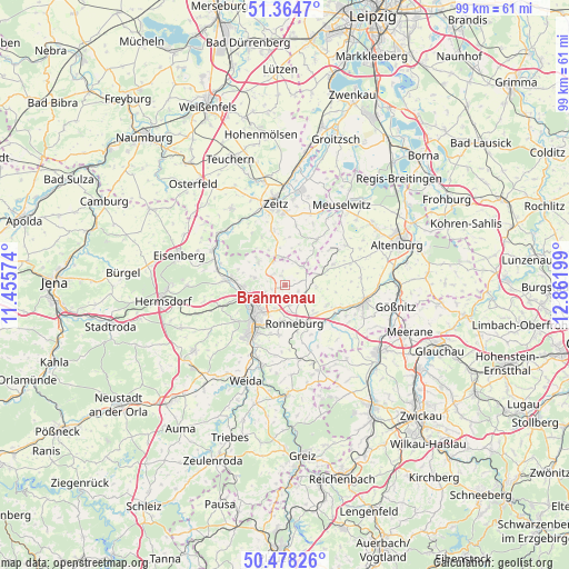
Brahmenau GPS coordinates[2]
50° 55' 24.924" North, 12° 9' 31.896" East
| Map corner | latitude | longitude |
|---|---|---|
| Upper-left | 51.3647°, | 11.45574° |
| Center: | 50.92359°, | 12.15886° |
| Lower-right: | 50.47826°, | 12.86199° |
| Map W x H: | 98.6×98.6 km | = 61.3×61.3mi |
| max Lat: | 55.01917° ⇑43.4% North |
| Brahmenau: | 50.92359° |
| min Lat: | ⇓56.6% South 47.40724° |
| min Long | Brahmenau | max Long |
| 5.92978° | 12.15886° | 14.98853° |
| W 84%⇐ | ⇒16% E |
Elevation
Elevation of Brahmenau is 250 m = 820 ft, and this is 0.90000000000001 m = 3 ft above average elevation for this country.
| Max E: |
1256 m = 4121 ft | 46.4% |
| Brahmenau | 250 m 820 ft | |
| Avg. | 249.1 m = 817 ft | |
Min E: |
-5 m = -16 ft | 53.6% |
See also: Germany elevation on elevation.city.
Geographical zone
Brahmenau is located in North temperate zone (between Tropic of Cancer and the Arctic Circle). Distance of this North polar circle is 1739 km =1080.6 mi to North.| Distance of | km | miles | from Brahmenau |
|---|---|---|---|
| North Pole | 4344.9 | 2699.8 | to North |
| Arctic Circle | 1739 | 1080.6 | to North |
| Tropic Cancer | 3056.3 | 1899.1 | to South |
| Equator | 5662.2 | 3518.3 | to South |


Nearby cities:
15 places around Brahmenau: (largest is in red/bold)
• Bethenhausen
2.9 km =1.8 mi,  77°
77°
• Dobitschen
9.3 km =5.8 mi,  66°
66°
• Gera
7.2 km =4.5 mi,  228°
228°
• Großenstein
3.9 km =2.4 mi,  132°
132°
• Hirschfeld
2.9 km =1.8 mi,  45°
45°
• Korbussen
3.8 km =2.4 mi,  165°
165°
• Lumpzig
8.1 km =5 mi, 68°
• Löbichau
8.1 km =5 mi,  114°
114°
• Paitzdorf
9.1 km =5.7 mi,  153°
153°
• Pölzig
4.1 km =2.5 mi,  44°
44°
• Ronneburg
7 km =4.3 mi,  163°
163°
• Schellbach
6.6 km =4.1 mi,  334°
334°
• Schwaara
2.5 km =1.6 mi,  206°
206°
• Wildenbörten
8.8 km =5.5 mi,  95°
95°
• Wittgendorf
6.5 km =4 mi,  22°
22°
Sources, notices
• [Note1] Compared only with cities in Germany existing in our database
• [Src1] Map data: © OpenStreetMap contributors (CC-BY-SA)
• [Src2] Other city data from geonames.org with taken over terms of usage.
• [Src3] Geographical zone / Annual Mean Temperature by Robert A. Rohde @ Wikipedia
