Edewecht geodata
Edewecht (Lower Saxony) is a populated place; located in Germany in Europe/Berlin (GMT+2) time zone. With population of 20,658 people, there are 744 cities with bigger population in this country. Compared to other cities in Germany, 82.4% of cities are located further ↓South; 77.3% of cities are located further →East and 95.2% of cities have higher elevation than Edewecht. Note1


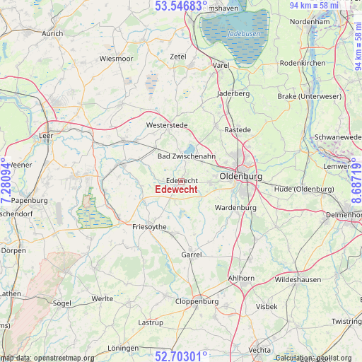
Edewecht GPS coordinates[2]
53° 7' 37.164" North, 7° 59' 2.616" East
| Map corner | latitude | longitude |
|---|---|---|
| Upper-left | 53.54683°, | 7.28094° |
| Center: | 53.12699°, | 7.98406° |
| Lower-right: | 52.70301°, | 8.68719° |
| Map W x H: | 93.8×93.8 km | = 58.3×58.3mi |
| max Lat: | 55.01917° ⇑17.6% North |
| Edewecht: | 53.12699° |
| min Lat: | ⇓82.4% South 47.40724° |
| min Long | Edewecht | max Long |
| 5.92978° | 7.98406° | 14.98853° |
| W 22.7%⇐ | ⇒77.3% E |
Elevation
Elevation of Edewecht is 8 m = 26 ft, and this is 241.1 m = 791 ft below average elevation for this country.
| Max E: |
1256 m = 4121 ft | 95.2% |
| Avg. | 249.1 m = 817 ft | |
| Edewecht | 8 m = 26 ft | |
Min E: |
-5 m = -16 ft | 4.8% |
See also: Germany elevation on elevation.city.
Geographical zone
Edewecht is located in North temperate zone (between Tropic of Cancer and the Arctic Circle). Distance of this North polar circle is 1494 km =928.3 mi to North.| Distance of | km | miles | from Edewecht |
|---|---|---|---|
| North Pole | 4099.9 | 2547.6 | to North |
| Arctic Circle | 1494 | 928.3 | to North |
| Tropic Cancer | 3301.2 | 2051.3 | to South |
| Equator | 5907.2 | 3670.6 | to South |


Nearby cities:
15 places around Edewecht: (largest is in red/bold)
• Apen
15.8 km =9.8 mi,  309°
309°
• Bad Zwischenahn
6.4 km =4 mi,  9°
9°
• Barßel
16.3 km =10.1 mi,  286°
286°
• Bösel
14.3 km =8.9 mi,  189°
189°
• Detern
22.6 km =14 mi, 293°
• Filsum
27 km =16.8 mi,  298°
298°
• Friesoythe
14.4 km =8.9 mi,  216°
216°
• Garrel
19.8 km =12.3 mi,  173°
173°
• Hilkenbrook
24.8 km =15.4 mi,  229°
229°
• Oldenburg
15.5 km =9.6 mi,  84°
84°
• Ostrhauderfehn
24.5 km =15.2 mi,  271°
271°
• Rastede
19.9 km =12.4 mi,  46°
46°
• Wardenburg
15.9 km =9.9 mi,  114°
114°
• Westerstede
14.9 km =9.3 mi,  345°
345°
• Wiefelstede
16.3 km =10.1 mi,  32°
32°
Sources, notices
• [Note1] Compared only with cities in Germany existing in our database
• [Src1] Map data: © OpenStreetMap contributors (CC-BY-SA)
• [Src2] Other city data from geonames.org with taken over terms of usage.
• [Src3] Geographical zone / Annual Mean Temperature by Robert A. Rohde @ Wikipedia
