Hude geodata
Hude (Lower Saxony) is a populated place; located in Germany in Europe/Berlin (GMT+2) time zone. With population of 15,567 people, there are 1032 cities with bigger population in this country. Compared to other cities in Germany, 82.3% of cities are located further ↓South; 71.4% of cities are located further →East and 92% of cities have higher elevation than Hude. Note1
Administrative division(s):
- Level 1: Lower Saxony
- Level 3: Landkreis Oldenburg
- Level 4: Hude (Oldenburg)


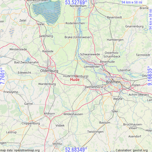
Hude GPS coordinates[2]
53° 6' 27.576" North, 8° 27' 47.592" East
| Map corner | latitude | longitude |
|---|---|---|
| Upper-left | 53.52769°, | 7.7601° |
| Center: | 53.10766°, | 8.46322° |
| Lower-right: | 52.68349°, | 9.16635° |
| Map W x H: | 93.9×93.9 km | = 58.3×58.3mi |
| max Lat: | 55.01917° ⇑17.7% North |
| Hude: | 53.10766° |
| min Lat: | ⇓82.3% South 47.40724° |
| min Long | Hude | max Long |
| 5.92978° | 8.46322° | 14.98853° |
| W 28.6%⇐ | ⇒71.4% E |
Elevation
Elevation of Hude is 16 m = 52 ft, and this is 233.1 m = 765 ft below average elevation for this country.
| Max E: |
1256 m = 4121 ft | 92% |
| Avg. | 249.1 m = 817 ft | |
| Hude | 16 m = 52 ft | |
Min E: |
-5 m = -16 ft | 8% |
See also: Germany elevation on elevation.city.
Geographical zone
Hude is located in North temperate zone (between Tropic of Cancer and the Arctic Circle). Distance of this North polar circle is 1496.2 km =929.7 mi to North.| Distance of | km | miles | from Hude |
|---|---|---|---|
| North Pole | 4102 | 2548.9 | to North |
| Arctic Circle | 1496.2 | 929.7 | to North |
| Tropic Cancer | 3299.1 | 2050 | to South |
| Equator | 5905 | 3669.2 | to South |


Nearby cities:
15 places around Hude: (largest is in red/bold)
• Burglesum
16.4 km =10.2 mi,  66°
66°
• Delmenhorst
12.8 km =8 mi,  119°
119°
• Dötlingen
20.1 km =12.5 mi,  195°
195°
• Elsfleth
14.4 km =8.9 mi,  358°
358°
• Ganderkesee
9.5 km =5.9 mi,  150°
150°
• Groß Ippener
18.7 km =11.6 mi, 146°
• Hatten
8.3 km =5.2 mi,  219°
219°
• Lemwerder
12.2 km =7.6 mi,  57°
57°
• Neuenkirchen
14.4 km =8.9 mi,  17°
17°
• Oldenburg
17 km =10.6 mi,  282°
282°
• Prinzhöfte
18.8 km =11.7 mi,  158°
158°
• Ritterhude
20 km =12.4 mi, 65°
• Schwanewede
16.7 km =10.4 mi,  33°
33°
• Vegesack
12.2 km =7.6 mi, 57°
• Wardenburg
18.2 km =11.3 mi,  255°
255°
Sources, notices
• [Note1] Compared only with cities in Germany existing in our database
• [Src1] Map data: © OpenStreetMap contributors (CC-BY-SA)
• [Src2] Other city data from geonames.org with taken over terms of usage.
• [Src3] Geographical zone / Annual Mean Temperature by Robert A. Rohde @ Wikipedia
