Dünsen geodata
Dünsen (Lower Saxony) is a seat of a fourth-order administrative division; located in Germany in Europe/Berlin (GMT+2) time zone. With population of 1,250 people, there are 6446 cities with bigger population in this country. Compared to other cities in Germany, 81.3% of cities are located further ↓South; 69.7% of cities are located further →East and 83.7% of cities have higher elevation than Dünsen. Note1


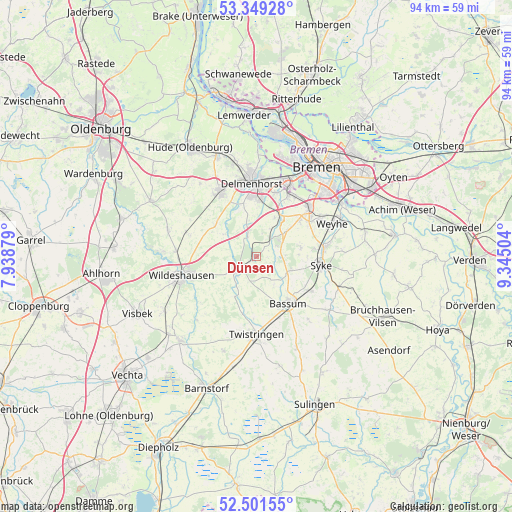
Dünsen GPS coordinates[2]
52° 55' 38.964" North, 8° 38' 30.876" East
| Map corner | latitude | longitude |
|---|---|---|
| Upper-left | 53.34928°, | 7.93879° |
| Center: | 52.92749°, | 8.64191° |
| Lower-right: | 52.50155°, | 9.34504° |
| Map W x H: | 94.3×94.3 km | = 58.6×58.6mi |
| max Lat: | 55.01917° ⇑18.7% North |
| Dünsen: | 52.92749° |
| min Lat: | ⇓81.3% South 47.40724° |
| min Long | Dünsen | max Long |
| 5.92978° | 8.64191° | 14.98853° |
| W 30.3%⇐ | ⇒69.7% E |
Elevation
Elevation of Dünsen is 38 m = 125 ft, and this is 211.1 m = 693 ft below average elevation for this country.
| Max E: |
1256 m = 4121 ft | 83.7% |
| Avg. | 249.1 m = 817 ft | |
| Dünsen | 38 m = 125 ft | |
Min E: |
-5 m = -16 ft | 16.3% |
See also: Germany elevation on elevation.city.
Geographical zone
Dünsen is located in North temperate zone (between Tropic of Cancer and the Arctic Circle). Distance of this North polar circle is 1516.2 km =942.1 mi to North.| Distance of | km | miles | from Dünsen |
|---|---|---|---|
| North Pole | 4122.1 | 2561.4 | to North |
| Arctic Circle | 1516.2 | 942.1 | to North |
| Tropic Cancer | 3279.1 | 2037.5 | to South |
| Equator | 5885 | 3656.8 | to South |


Nearby cities:
15 places around Dünsen: (largest is in red/bold)
• Bassum
10.3 km =6.4 mi,  145°
145°
• Beckeln
7.8 km =4.8 mi,  210°
210°
• Colnrade
14.9 km =9.3 mi,  225°
225°
• Delmenhorst
13.8 km =8.6 mi,  356°
356°
• Dötlingen
17.3 km =10.7 mi,  272°
272°
• Ganderkesee
13.8 km =8.6 mi,  328°
328°
• Groß Ippener
4.7 km =2.9 mi,  338°
338°
• Harpstedt
4 km =2.5 mi,  240°
240°
• Kirchseelte
3.7 km =2.3 mi,  47°
47°
• Prinzhöfte
5.6 km =3.5 mi,  296°
296°
• Stuhr
13.8 km =8.6 mi,  31°
31°
• Syke
12.2 km =7.6 mi,  97°
97°
• Twistringen
14.3 km =8.9 mi,  180°
180°
• Wildeshausen
14.4 km =8.9 mi,  255°
255°
• Winkelsett
9.9 km =6.2 mi, 227°
Sources, notices
• [Note1] Compared only with cities in Germany existing in our database
• [Src1] Map data: © OpenStreetMap contributors (CC-BY-SA)
• [Src2] Other city data from geonames.org with taken over terms of usage.
• [Src3] Geographical zone / Annual Mean Temperature by Robert A. Rohde @ Wikipedia
